|
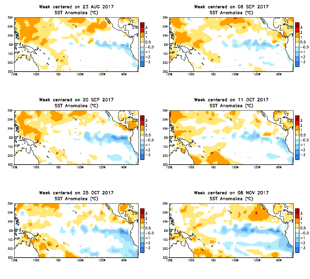
The likelihood of a La Niña is looking better and better. There is now a 65-70% chance a La Niña will develop through this upcoming winter. I could explain all about it, but this ENSO blog is a great resource: https://www.climate.gov/news-features/department/enso-blog
1 Comment
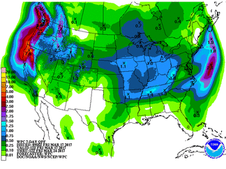
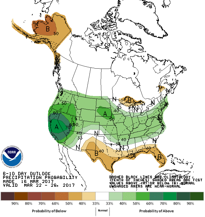
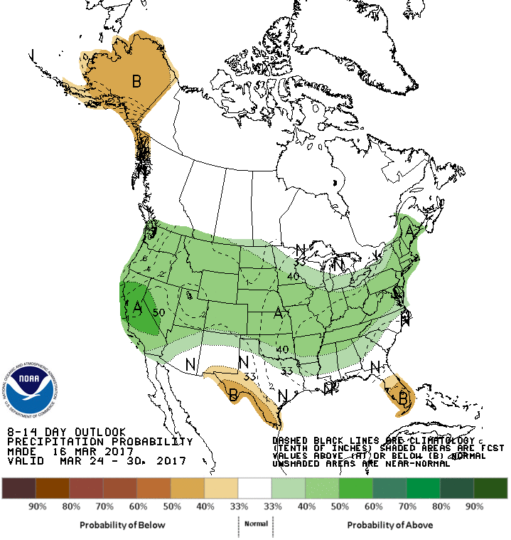
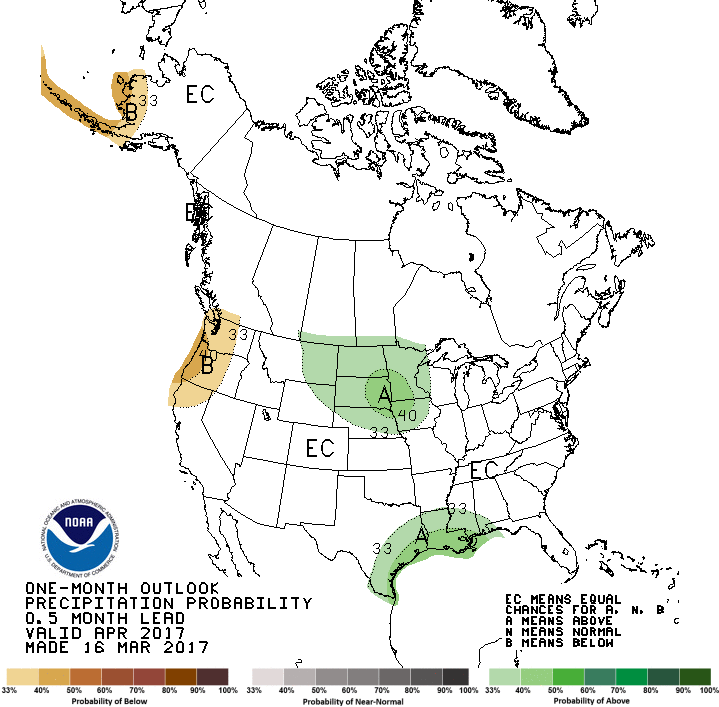
All indications point to a wet pattern ahead for Nebraska and much of the crop growing region. The short-term forecast and extended forecast suggest that we could see above normal moisture to start planting season. After a warm and fairly dry February and early March, the end of the month and start to April may be the opposite. For many locations, some early season moisture would be welcome to add moisture to the top soil and to kick-start pasture growth. This may hinder field activities and planting date; however, what happens the last half of April will determine a lot.
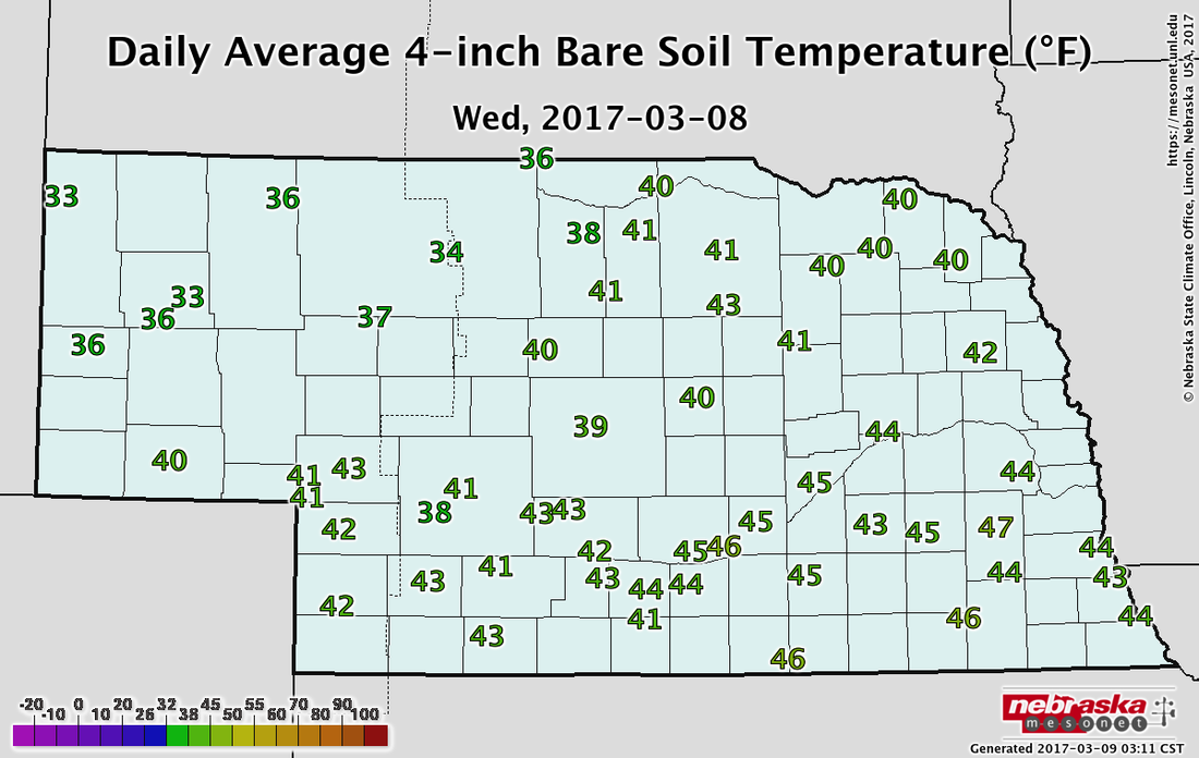
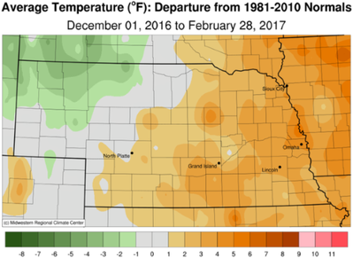
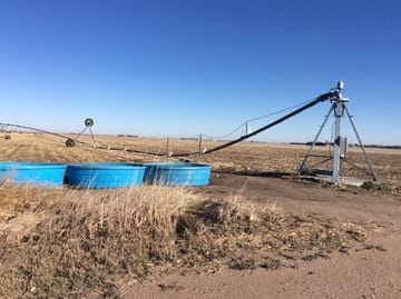
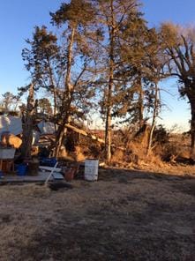
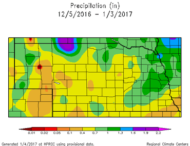
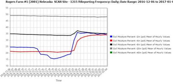
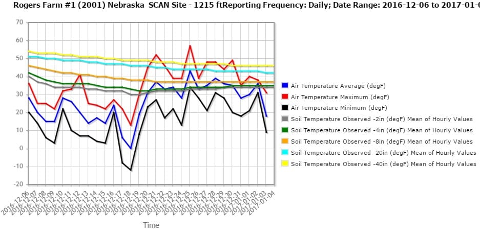
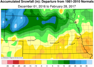 The Good The temperature pattern tells two different stories during the meteorological winter (Dec.—Feb) in Nebraska. Three-month average temps in NW Nebraska were nearly 5°F below normal and temps were 5°F above normal in the eastern 1/2 of the state. After a warm fall, temperatures plummeted in mid-December and early January. Temperatures dropped to more 30°F below zero in some locations, which were some of the coldest temperatures we have had in a few years. February told a different story with extreme minimums dropping to -10°F in the NW and 12°F in the SE. Max temps in February reached near 80°F in southern Nebraska to the upper 60s and low 70s in the northwest and northeast. February ended up being the 9th warmest February on record for Nebraska and the three-month, winter-time average was the 27th warmest on record. Current 4” soil temperatures are in the mid 30s in the west to mid 40s in the east. Some locations in central and southeast NE have had soil temps range from the upper 50s/ low 60s to near freezing, just in the past seven days. The Bad The precipitation pattern this winter also mimicked the temperature pattern. Whether we like it or not, snow is needed in Nebraska, but too much (or too little) can create challenges. Northwest NE saw plenty of snow since December 1st (50-60”) and ended up 20-30” above normal. This is beneficial to winter wheat, especially since temperatures were bitterly cold at times this winter. The southern 1/3 of Nebraska was 10-15” below normal with much of the area receiving less than 10-15” of snow. For overall precipitation, most of the state ended up within an inch above or below normal for the winter, due to the multiple rain events in December and January that offset a lack of snowfall for many areas. For soil moisture, the southwest portion of the state is much below normal and in moderate drought conditions. Most of the state has adequate rootzone moisture, but surface moisture is lacking in a number of locations due to warm temperatures and high winds. This has caused blowing dust and wildfires across Nebraska and the central plains. The dryness in southern NE needs to be monitored closely. 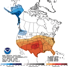 The Outlook Spring is here (at least the meteorological spring); however, the forecast is going to look like winter for the next few days. A trough will set up over the northeast U.S., and northwest flow will dominate our region bringing in cooler air. A number of disturbances will track across the northern plains, with most of the snow from this to be outside of Nebraska, however, eastern Nebraska will likely get some of the snow. Nonetheless, cooler temperatures will dominate with a strong temperature gradient from NE to SW Nebraska. Temps will struggle to get above freezing in the northeast, while the southwest could see 40s and 50s (maybe 60s). Lows could dip down into the single digits in far northeast Nebraska and may cause some issues on early spring growth. Official snow forecasts haven't been released for the entire event, but there are potentially three precipitation events that look to track across northeast Nebraska through Tuesday. Temperatures begin to warm back up the middle of next week, however, snow covered areas will recover more slowly. The 6-10 and 8-14 day forecasts are showing a strong warm up for the central plains as the jet stream appears to push further to the north next week. This northern push will also take most of the precipitation chances with it. If the models are right, we could see very warm temperatures next weekend before a number of disturbances make their way back into the area. The models are all over the place to end the month, so we could see a fairly turbulent last couple weeks of the month. The long-term outlook for the spring and even into the summer is where it becomes more important, but even more challenging. The last couple years have seen early warm-ups followed by an abnormally wet April. The most recent 30 year trend has shown a significant increase in April precipitation for most of Nebraska. Mother Nature doesn’t follow an exact calendar, but we typically follow up these warm, dry spells with a bout of cool, wet weather. The question is if our cool, wet weather will come at the end of March and start of April or will it come at the end of April similar to 2016? The La Niña is dwindling, but the cold water in the N. Pacific is causing our weather to behave similar to La Niña conditions. This opens up the question of dryness later in the season. It appears we may pick up some decent moisture over the next 2-4 weeks and we may need that going forward. Tyler Williams, Nebraska Extension Educator Cropping Systems and Climate Resiliency 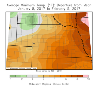 The Good Recently, temperatures have been relatively mild after a roller coaster ride the first part of winter. Minimum temps over the last 30 days have been near average (NW) to 6-8°F above average (SE) and high temps have been near average (NW) to 2-4°F above average (SE). This has allowed soil temps at the 4” depth to maintain near the freezing mark for most of Nebraska after a very cold end to December and start to January. Maximum temps reached the mid 60s in the south to the upper 40s in the northwest with a range of temperatures in between. The minimum temps ranged from –3 to –5°F in the east to –25 to –30°F in the west. Our climatological coldest day of the year is the second week of January, so things are looking up from here. 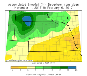 The Bad The lack of snowfall for many people may be seen as a positive; however, snow cover provides some agronomic benefits. Even though we have had near normal precipitation this winter, much of that fell as rain, and the snow we did receive melted quickly. Snow cover acts as insulation for the soil ecosystem, and over-wintering crops such as wheat rely on that protective layer during cold out-breaks. Northwest Nebraska did get more than their fare share of snow and received upwards of 30-40” since Nov. 1, which is 15-20” above average. Southeast Nebraska is 10-15” below average for the season with only a few inches of total snowfall. Even with the snow in NW Nebraska, almost the entire state is snow-free as of Feb. 6. January ended up having above normal precipitation, but was not in the form of snow for most areas. 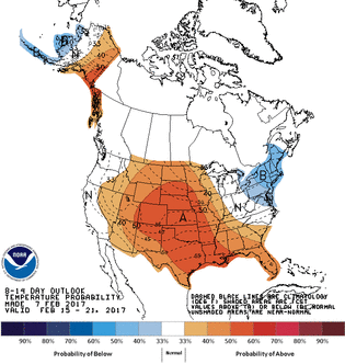 The Outlook The forecast for the next couple weeks generally looks warm. A system will move through tonight and tomorrow, which will bring in some snow and a cool down. Temperatures will rebound by the end of the week, possibly into the 50s and 60s; however, the amount of snow cover will make a difference in how quickly we rebound and how warm we will get. Portions of western and northern Nebraska are expected to get accumulating snow, so this will keep air temperatures cooler than if we would have bare ground. A strong ridge will build in and push the northern jet stream far to the north and east after this system moves through allowing us to warm up. Precipitation looks minimal (after tonight) for the next week. A cutoff low is expected to form over the desert southwest early next week and slowly trek across the southern plains It’s path will impact our temps and precipitation chances. For the extended outlook, it appears we are setting into our late winter pattern with a ridge in the western U.S. and a trough in the eastern U.S. This pattern typically brings in cooler temperatures for eastern Nebraska and warmer temps for the western portions. The location of the jet stream will determine how cold or how warm, but you can still expect that temperature gradient from east to west. The Climate Prediction Center outlooks for February 12-20th have much of the U.S. with increased odds for above normal temperatures, with the highest confidence over the central plains. This pattern aligns with the CPC’s February outlook of higher chances for above normal temperatures. The best odds for precipitation remain on the coasts. The long-term outlook for the next few months is still quite uncertain for Nebraska. The current La Nina is expected to diminish, but the cool water in the northern Pacific may still play a role in the upcoming weather pattern. It has certainly played a role in the precipitation pattern for California the last couple months. Tyler Williams, Nebraska Extension Educator Cropping Systems and Climate Resiliency [email protected] 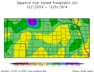 The Good This past month finally featured near normal precipitation amounts for the state. Although it was light, and some of it fell on frozen soil, it had been a few months since we last saw near normal precipitation for the region. Most of the state was within 0.5” of normal, but “normal” is only about 0.5” in the west and 1-1.5” in the east. The highest values were near 2” around Omaha to less than 0.1” in the southwest. Winter precipitation only accounts for a small percentage of our annual precipitation; however, it can be important when it comes to winter wheat and spring soil moisture. We also finished the month 2°F (east) to 8°F (west) below normal for average temperature, but that probably doesn’t belong in the “Good” section. The Bad The bad this month, believe it or not, is severe weather. Tornadoes touched down in Nebraska on Christmas Day near Funk, Gibbon, and Minden and did damage to buildings, power poles, and pivots. These are the ‘latest calendar year’ tornadoes in Nebraska since at least 1950 (records available) and are the first December tornadoes since 1975. The storms also produced damaging winds that were more widespread. You may also remember on November 27th, there were tornadoes near Upland, Red Cloud and Lawrence and were the second ‘latest calendar day’ tornadoes on record. They are now the third latest, thanks to our Christmas Day tornadoes. Apparently, we now need weather radios alongside snow blowers in the winter weather section at the hardware stores. 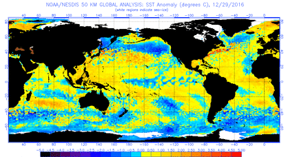 The Outlook Our string of winter-like temperatures is expected to continue through the week with a warm up into the 20s by the weekend and possibly upper 30s by Sunday (heat wave!). A band of snow moved through Nebraska recently and that may keep temperatures in those areas cooler than surrounding areas. The models are showing a little relief the middle of next week before another push of cold air comes in from the north. It appears northeast and southwest Nebraska could see much different conditions next week due to the location of next week’s front. It looks like the jet stream will separate the moderate and very cold temperatures and will position itself over Nebraska. That is not uncommon in Nebraska, but is a typical late-winter feature. Precipitation this time of year is very challenging, but it does appear a number of disturbances will be moving across the central plains over the next week or two. The middle of next week will be worth watching as temperatures warm and moisture comes in from the south ahead of the next cold front. A tenth of an inch of liquid-equivalent precipitation can ruin your day, so it doesn’t take much to make the ground white. The forecast for the rest of the month is expected to be near normal, but it will feel like a roller coaster for temperature. These cold blasts will be followed by a sharp warm up and this all averages out to be near normal, even thought it won’t feel like it. (The easy part of long-term forecasting!) Historically, the coldest week of the year is next week, so after that, we should be on a warming trend! La Niña: Our weather continues to mimic a “typical” La Niña with abnormally cold in the north and warm in the south. Ocean temperatures are still showing La Niña conditions and the models have this diminishing in a couple months. HOWEVER, there is a cold pool of water in the northern pacific that may throw a wrinkle into this. We can see this already with the precipitation in California, which is typically much further north over the Pacific Northwest. Will this cold water slow down the expected diminishing of La Niña? A La Niña spring is dry and cool with dry and warm summer; however, the confidence is weak. Tyler Williams, Nebraska Extension Educator Cropping Systems and Climate Resiliency [email protected] On Christmas Day, an abnormal storm system moved through the middle of the U.S. and brought severe weather, heavy rain, and tornadoes to central and eastern Nebraska. In addition to the highly publicized wind and tornado damage, some portions of Nebraska received some beneficial precipiation. Areas from York to Lincoln and up towards Sioux City recieved a half inch or more of liquid precipiation. The SCAN (NRCS monitoring site) station 10 miles east of Lincoln shows a sharp increase in soil moisture percent at the 2 and 4 inch depth (below). Thanks to a week of warm temperatures, the soil temperatures (below) were able to come up above freezing and allow some of the moisture to infiltrate into the soil. The top soil was fairly dry before the rainfall due to a couple months of below normal precipiation and much above normal temperatures. Believe it or not, but this moisture will be beneficial come this spring.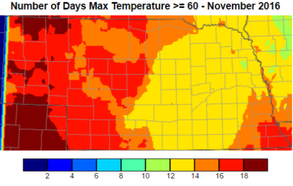 The Good For the third month in a row, abnormally warm temperatures have been the story. The 30-year normal maximum temperature for November ranges from the low 50s in the south to the upper 40s in the north and we surpassed that quite often. The state had 12-20 days in November where the high was above 60°F and some spots had 5-6 days with temperatures greater than 75°F. Monthly lows were 5-8°F (west) to 21-23°F (east). Highs were 82-84°F (central and south) to 72-74°F (northeast and west). Soil temperatures at 4” are in the upper 30s in the east and low 30s in the west. At least we have unfrozen soils and any precip will soak in. 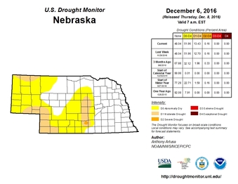 The Bad Not a lot in agriculture is dependent on the November weather, so not a lot can go wrong; however, the warm temps have continued to dry out the soil (with minimal precip), increase pest pressure in wheat, delay anhydrous application, and encourage more tillage. Soil moisture continued to decrease for most of the state, especially in the west, and some areas of moderate drought remained. Stripe rust, grasshoppers, and other pests have damaged a decent winter wheat crop due to extended freeze-free period. Soil temperatures recently (last couple weeks) dropped below 50°F for the state in order for anhydrous ammonia applications to be relatively successful. There also was an abundance of field work due to the quick harvest and nice weather. There are many, many benefits to leaving residue and utilizing no-till practices, but this may not seem like a “bad” thing to some. The Outlook
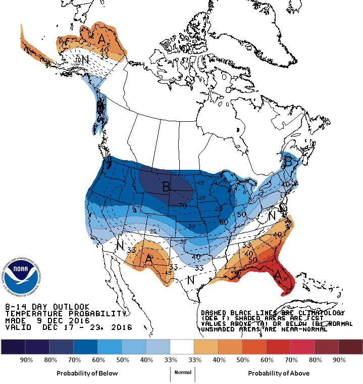
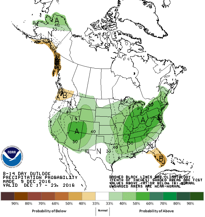
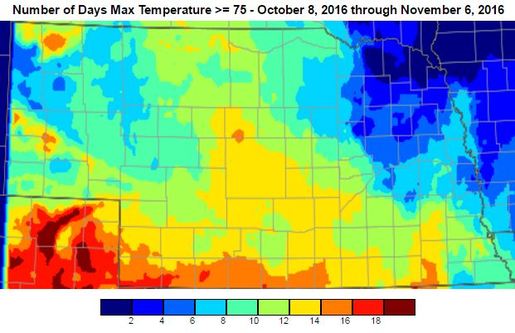
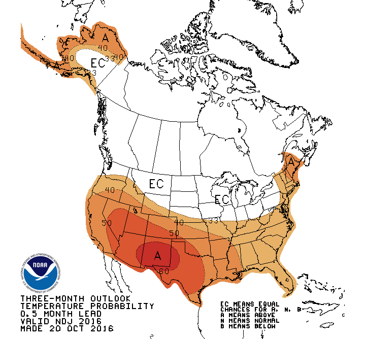
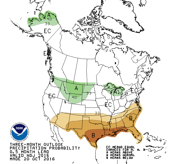
The recent forecasts have only been accurate out to a few days, so this forecast may be about the same, but we do know that our honeymoon of warm temperatures is over for a while. Arctic air has finally made its push down into the northern plains and we will barely get above freezing through the weekend. This big push of cool air diminished our chances for “snow-maggedon” because the high pressure pushed the system south of our region and brought in much drier air. Overall, the next 5-7 days appears to be cool, mostly dry with a relatively uneventful pattern. Looking past this weekend, the models are not showing any time of pattern-changing system to move through. Temperatures will be moderate to start next week, but may bottom out again the middle of next week. The models are picking up on another push of arctic air down into the center of the U.S. and we could see very cold temperatures. The 6-10 and 8-14 Day Outlooks from the CPC continue to forecast increased high chances fore below normal temperatures for the northern part of the U.S. The latter part of the forecast period (next weekend and beyond) does show a hint of a potential warming trend; however, the models have been hinting at this for a while and it keeps getting pushed back and I will believe that when I see it. The precipitation is forecasted to be near to above normal for our region with the heaviest moisture in the west and east, but it doesn’t take much moisture to be “normal”. The extended outlook for the rest of the month and winter, in short, looks cold. La Niña typically brings in colder than normal temps during the winter for the northern plains. Lately, our weather has mimicked La Niña patterns, so we could see this continue IF La Niña does not dissipate. Be looking for big temperature swings the next couple months with below normal precipitation. Winter is here. Tyler Williams, Nebraska Extension Educator Cropping Systems and Climate Resiliency 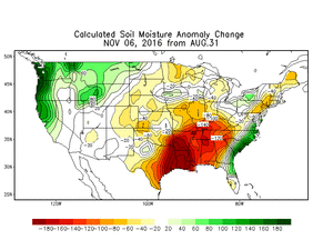 The Good For most people in Nebraska, the weather the past few weeks has been fantastic. Average temperatures over the last 30 days have been 6-8°F above normal for almost the entire state. The average highs in October ranged from the mid 70s in the southwest to the mid 60s in the northeast. Average lows were mid 40s in the southeast and mid 30s in the panhandle. The first week of November has been much of the same many of us haven’t seen freezing temperatures for quite some time. The Bad Warm temperatures in the fall are often accompanied by dry conditions and that is exactly what we got. Last month, “The Bad” was also a lack of precipitation, and we added about 30 days of dryness to that. Almost all of the state received less than 0.50” over that past 30 days, which is 0.5-2.0” below normal. The dry and warm weather continued to dry out the soil, even with decreasing daylight hours. This has limited potential wheat and cover crop growth and ended the pasture grazing season a little early.
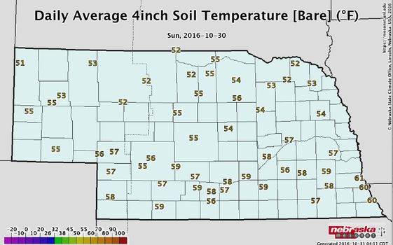
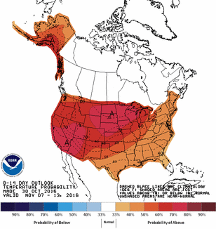 It is recommended for producers to delay anhydrous ammonia applications until soil temperatures drop below 50 degrees F, since the conversion of ammonium to nitrate slows considerably below 50 degrees; however, it is wise to wait until soil temps have remained under 50 degrees for a week or so. Nitrification inhibitors may be used to apply the fertilizer on warmer soils, but be sure to follow product recommendations and restrictions. Currently, soil temperatures at a 4" depth under bare soil are in the low 50s in western NE to the upper 50s and low 60s in the southeast. Soil temperatures, especially under bare soil can fluctuate quite a bit from day to day AND from morning to afternoon. Current soil temperatures can be found at the Nebraska Mesonet (mesonet.unl.edu), which is part of the Nebraska State Climate Office or can be found at CropWatch (cropwatch.unl.edu). These soil temperatures are the average of the entire day, so take that into account, if you are taking your own soil temperatures at a single point during the day. There can be quite a difference between the two. With harvest quickly winding down, you may want to get moving on anhydrous applications, but the forecast for the next 10-14 days does not look like soil temperatures will drop very fast. The Climate Prediction Center 8-14 day outlook has a 70% probability for Nebraska having above normal temperatures for that time period. The normal daily high to start November is in the upper 50s. *Anhydrous ammonia applications in the fall are not recommended for coarse textured soils due to leaching potential or areas with other application restrictions. 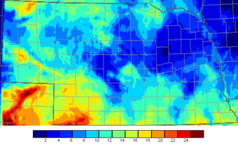 Number of days above 90°F in August and September Number of days above 90°F in August and September The Good The temperature pattern over the last 30-60 days has been quite favorable for Nebraska. We had some days that reached the upper 90s, but, overall, the temperature pattern has been near to slightly above normal for most of the state. September started with cool temperatures, but the last week or two has yielded some of the best weather Nebraska has to offer. 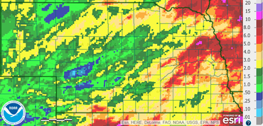 Radar estimated precipitation for September 2016 Radar estimated precipitation for September 2016 The Bad After a rather wet growing season for Nebraska (except for a few locations), we have recently turned dry. Even though many of the crops are mature, late-planted and long-season crops were still using moisture over the last few weeks. Over the last 30 days, portions of central and northwest Nebraska were the driest with less than a half of an inch of precipitation, with a few bands of higher amounts. In general, the state dried out significantly west of Grand Island. This may shorten the grazing season on some pastures and may have aided in early senescence in dryland fields. 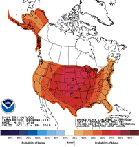 The Outlook Temperatures will gradually cool down the rest of this week and have multiple chances for precipitation. The coldest day will be Thursday and best chance for frost is Friday and Saturday morning. It looks like a VERY good chance of sub 32°F temps for the western half of the state with mid 20s in the far west. The big weather system will slide east through the weekend and we will begin to warm up and dry out. The weather will remain relatively quiet and uneventful most of next week, so should have another long streak of good harvest weather. Temperatures will be warm during the day and cool off during the night, so get used to running your heater and A/C in the same day. Looking further out, we may settle into a pattern of these deep systems moving through every one to two weeks or so, and each one will bring in cooler temperatures than the previous. The Climate Prediction Center (CPC) is forecasting generally above normal temperatures for Nebraska for October 10-18, as well as their October outlook that gives us slightly higher odds for above normal temperatures. Precipitation is a little less confident and will most likely be near to below normal for the rest of the month, depending on the speed of some of the upcoming frontal passages. There seems to be some confidence that we will not see a big wash-out over the next couple weeks. La Niña is becoming less of a factor, thus it is not discussed and the winter forecast is a coin toss for Nebraska. Tyler Williams, Nebraska Extension Educator Cropping Systems and Climate Resiliency [email protected], agclimatenebraska.weebly.com |
AuthorI study weather and climate impacts on agriculture, climate variability, and using weather and climate information to make better agricultural decisions. Archives
November 2017
|
| Ag Climate Nebraska |
|
 RSS Feed
