The Good
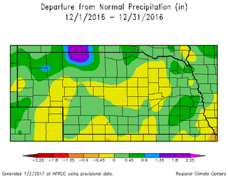
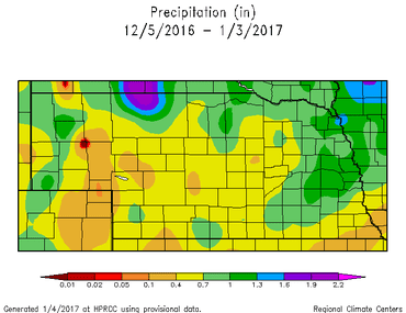
This past month finally featured near normal precipitation amounts for the state. Although it was light, and some of it fell on frozen soil, it had been a few months since we last saw near normal precipitation for the region. Most of the state was within 0.5” of normal, but “normal” is only about 0.5” in the west and 1-1.5” in the east. The highest values were near 2” around Omaha to less than 0.1” in the southwest. Winter precipitation only accounts for a small percentage of our annual precipitation; however, it can be important when it comes to winter wheat and spring soil moisture. We also finished the month 2°F (east) to 8°F (west) below normal for average temperature, but that probably doesn’t belong in the “Good” section.
This past month finally featured near normal precipitation amounts for the state. Although it was light, and some of it fell on frozen soil, it had been a few months since we last saw near normal precipitation for the region. Most of the state was within 0.5” of normal, but “normal” is only about 0.5” in the west and 1-1.5” in the east. The highest values were near 2” around Omaha to less than 0.1” in the southwest. Winter precipitation only accounts for a small percentage of our annual precipitation; however, it can be important when it comes to winter wheat and spring soil moisture. We also finished the month 2°F (east) to 8°F (west) below normal for average temperature, but that probably doesn’t belong in the “Good” section.
The Bad
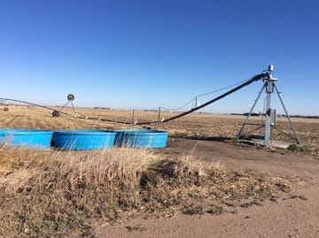
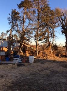
The bad this month, believe it or not, is severe weather. Tornadoes touched down in Nebraska on Christmas Day near Funk, Gibbon, and Minden and did damage to buildings, power poles, and pivots. These are the ‘latest calendar year’ tornadoes in Nebraska since at least 1950 (records available) and are the first December tornadoes since 1975. The storms also produced damaging winds that were more widespread. You may also remember on November 27th, there were tornadoes near Upland, Red Cloud and Lawrence and were the second ‘latest calendar day’ tornadoes on record. They are now the third latest, thanks to our Christmas Day tornadoes. Apparently, we now need weather radios alongside snow blowers in the winter weather section at the hardware stores.
The bad this month, believe it or not, is severe weather. Tornadoes touched down in Nebraska on Christmas Day near Funk, Gibbon, and Minden and did damage to buildings, power poles, and pivots. These are the ‘latest calendar year’ tornadoes in Nebraska since at least 1950 (records available) and are the first December tornadoes since 1975. The storms also produced damaging winds that were more widespread. You may also remember on November 27th, there were tornadoes near Upland, Red Cloud and Lawrence and were the second ‘latest calendar day’ tornadoes on record. They are now the third latest, thanks to our Christmas Day tornadoes. Apparently, we now need weather radios alongside snow blowers in the winter weather section at the hardware stores.
 |  |
The Outlook
Our string of winter-like temperatures is expected to continue through the week with a warm up into the 20s by the weekend and possibly upper 30s by Sunday (heat wave!). A band of snow moved through Nebraska recently and that may keep temperatures in those areas cooler than surrounding areas. The models are showing a little relief the middle of next week before another push of cold air comes in from the north. It appears northeast and southwest Nebraska could see much different conditions next week due to the location of next week’s front. It looks like the jet stream will separate the moderate and very cold temperatures and will position itself over Nebraska. That is not uncommon in Nebraska, but is a typical late-winter feature.
Precipitation this time of year is very challenging, but it does appear a number of disturbances will be moving across the central plains over the next week or two. The middle of next week will be worth watching as temperatures warm and moisture comes in from the south ahead of the next cold front. A tenth of an inch of liquid-equivalent precipitation can ruin your day, so it doesn’t take much to make the ground white.
The forecast for the rest of the month is expected to be near normal, but it will feel like a roller coaster for temperature. These cold blasts will be followed by a sharp warm up and this all averages out to be near normal, even thought it won’t feel like it. (The easy part of long-term forecasting!) Historically, the coldest week of the year is next week, so after that, we should be on a warming trend!
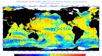
La Niña: Our weather continues to mimic a “typical” La Niña with abnormally cold in the north and warm in the south. Ocean temperatures are still showing La Niña conditions and the models have this diminishing in a couple months. HOWEVER, there is a cold pool of water in the northern pacific that may throw a wrinkle into this. We can see this already with the precipitation in California, which is typically much further north over the Pacific Northwest. Will this cold water slow down the expected diminishing of La Niña? A La Niña spring is dry and cool with dry and warm summer; however, the confidence is weak.
Tyler Williams, Nebraska Extension Educator
Cropping Systems and Climate Resiliency
[email protected]
Our string of winter-like temperatures is expected to continue through the week with a warm up into the 20s by the weekend and possibly upper 30s by Sunday (heat wave!). A band of snow moved through Nebraska recently and that may keep temperatures in those areas cooler than surrounding areas. The models are showing a little relief the middle of next week before another push of cold air comes in from the north. It appears northeast and southwest Nebraska could see much different conditions next week due to the location of next week’s front. It looks like the jet stream will separate the moderate and very cold temperatures and will position itself over Nebraska. That is not uncommon in Nebraska, but is a typical late-winter feature.
Precipitation this time of year is very challenging, but it does appear a number of disturbances will be moving across the central plains over the next week or two. The middle of next week will be worth watching as temperatures warm and moisture comes in from the south ahead of the next cold front. A tenth of an inch of liquid-equivalent precipitation can ruin your day, so it doesn’t take much to make the ground white.
The forecast for the rest of the month is expected to be near normal, but it will feel like a roller coaster for temperature. These cold blasts will be followed by a sharp warm up and this all averages out to be near normal, even thought it won’t feel like it. (The easy part of long-term forecasting!) Historically, the coldest week of the year is next week, so after that, we should be on a warming trend!
La Niña: Our weather continues to mimic a “typical” La Niña with abnormally cold in the north and warm in the south. Ocean temperatures are still showing La Niña conditions and the models have this diminishing in a couple months. HOWEVER, there is a cold pool of water in the northern pacific that may throw a wrinkle into this. We can see this already with the precipitation in California, which is typically much further north over the Pacific Northwest. Will this cold water slow down the expected diminishing of La Niña? A La Niña spring is dry and cool with dry and warm summer; however, the confidence is weak.
Tyler Williams, Nebraska Extension Educator
Cropping Systems and Climate Resiliency
[email protected]
 RSS Feed
