Ag Climate Nebraska
Climate, weather, and agricultural information for Nebraska
  • Home
  • Climate and Weather Resources
  • About/Contact

Latest Drought Monitor

4/28/2016

0 Comments

 
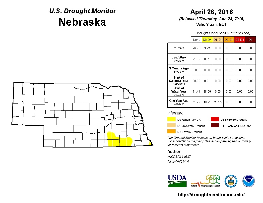
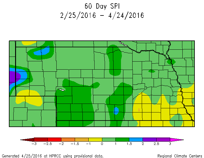
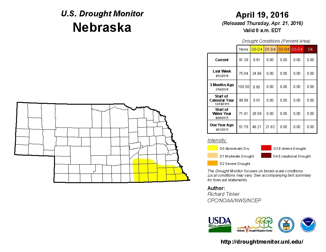
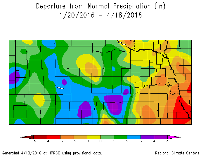
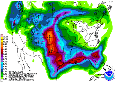
As expected, the "abnormally dry" area decreased in Nebraska in the latest Drought Monitor.  A small area in south central/southeast Nebraska remains even after moderate precipitation this past week.  This area is still trending below normal precipitation in the window between 30-90 days ago, but rain in the forecast  just might eliminate all of the Drought Monitor colors in Nebraska by this time next week.  
Picture
0 Comments

Weather and Climate - Latest on Nebraska

4/25/2016

0 Comments

 
Here is a map and short-text version of the latest weather and climate news in Nebraska.  
Neb Rundown:
- March was 5th warmest on record and near normal for precipitation.
- 60-Day SPI (Standardized Precipitation Index) shows a deficit in SE Neb, which mimics the Drought Monitor.  SPI is typically used to detect drought conditions during the growing season.  Recent rain may alter the next drought monitor.  
- Estimated rainfall over the last 14 days saw 3-4" covering 2/3 of the state
- 14-Day average temperature was 2-6 degrees F above normal
Forecast
- Severe weather is expected Tuesday for the Central Plains.  Large hail and strong tornadoes possible from southern Nebraska to southern Oklahoma.  Storms will initiate on warm front in Nebraska, so location of warm front in late afternoon/evening will be the key.
- 7-Day precipitation forecast (QPF) shows a lot of moisture in Central Plains, up to 5"+ in E. Neb.
​- 8-14 Day Outlook (thru May 2-9) shows below normal temps and above normal precip during that time period for Nebraska and large portion of U.S., but could be transitioning back to warmer weather during this first week of May.  Cool over the next 10 days, but does not look like hard frost risk.  Get used to the 50s and 60s for highs for a while.
Picture
8-14 Day Temp Outlook
Picture
April 26 (Tues) Severe Outlook
Picture
8-14 Day Precip Outlook
Picture
7-Day QPF
Picture
14-Day Radar Estimated Precip
Picture
Picture
Picture
Picture
0 Comments

7-Day Precipitation and 90-Day Deficit

4/19/2016

0 Comments

 
Plenty of precipitation in the central 1/3 of the state, but a 90-day (and 30, 60-day) precipitation deficit still remains in the eastern 1/3.  More chances for rain on the way over the next two weeks.  
Picture
7-Day (4/19) Radar Estimate Rainfall

Picture
0 Comments

Planting and Weather

4/13/2016

0 Comments

 
Picture
The calendar and mother nature says it is time for planting, so the fields are busy this week.  The weather looks to be very good for planting for the next couple days with a big system expected to move through Friday through Sunday/Monday.  Yes, that is 3 or 4 days for a system to move through, which is uncommon.  This is a very amplified system and will produce a lot of moisture for someone, but probably not everyone.  The 7-Day QPF shows most of the moisture in the western half of Nebraska.  These values are very, very high and would pose significant issues with runoff, erosion, lowland flooding, or even heavy snow for far west portions of Nebraska.  We will know more in the coming days, but precipitation is quite likely for most of the state at this point.  A little moisture would be good for germination and recharge, but anything over a couple inches will run off the fields and cause problems.  
​

Picture
Picture
The forecast for the next couple weeks looks to stay warm and relatively dry.  We will see how the upper air pattern shakes out after this big system this weekend, but it looks to get back to near normal conditions over the next couple weeks.  It seems there is a tendency during the spring to get these repetitive storm systems with similar storm tracks; however, the models aren't really picking this up yet.  Just something to be thinking about.  We saw that type of thing happen last spring in Texas and Oklahoma, as well as Eastern Nebraska.  This is quite an anomalous storm system, so could be a one-time show.  The CPC Outlooks keep us warm and near normal moisture through next weekend.  ​
0 Comments
    Click for the Nebraska Ag Climate Update survey.  Your participation is appreciated.

    ​Ag Climate  Update Archive

    Tweets by @tylerw_unl
    UNL CropWatch
    GDD & ET Data
    National Weather Service
    Climate Prediction Center
    High Plains Regional Climate Center
    National Drought ​Mitigation Center

    Author

    I study weather and climate impacts on agriculture, climate variability, and using weather and climate information to make better agricultural decisions. 

    -Tyler Williams
    University of Nebraska - Lincoln Extension Educator
    Cropping Systems

    B.S. Meteorology/Climatology
    M.A.S. Agronomy


    Archives

    March 2017
    February 2017
    January 2017
    December 2016
    November 2016
    October 2016
    September 2016
    August 2016
    July 2016
    June 2016
    May 2016
    April 2016
    February 2016
    January 2016
    December 2015
    November 2015
    October 2015
    September 2015
    August 2015
    July 2015
    June 2015
    May 2015
    April 2015
    March 2015
    February 2015
    January 2015
    November 2014
    October 2014
    September 2014
    August 2014
    July 2014
    June 2014
    May 2014
    April 2014
    March 2014
    February 2014
    January 2014
    December 2013

    RSS Feed

Powered by Create your own unique website with customizable templates.