Ag Climate Nebraska
Climate, weather, and agricultural information for Nebraska
  • Home
  • Climate and Weather Resources
  • About/Contact

Soil temperatures not ready for anhydrous

10/31/2016

1 Comment

 
Picture
Picture
It is recommended for producers to delay anhydrous ammonia applications until soil temperatures drop below 50 degrees F, since the conversion of ammonium to nitrate slows considerably below 50 degrees; however, it is wise to wait until soil temps have remained under 50 degrees for a week or so.  Nitrification inhibitors may be used to apply the fertilizer on warmer soils, but be sure to follow product recommendations and restrictions.

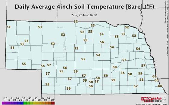
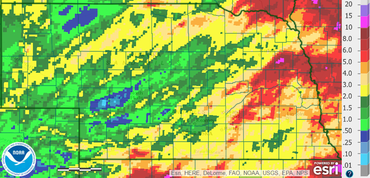
Currently, soil temperatures at a 4" depth under bare soil are in the low 50s in western NE to the upper 50s and low 60s in the southeast.  Soil temperatures, especially under bare soil can fluctuate quite a bit from day to day AND from morning to afternoon.  

Current soil temperatures can be found at the Nebraska Mesonet (mesonet.unl.edu), which is part of the Nebraska State Climate Office or can be found at CropWatch (cropwatch.unl.edu).  These soil temperatures are the average of the entire day, so take that into account, if you are taking your own soil temperatures at a single point during the day.  There can be quite a difference between the two.

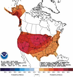
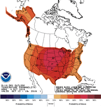
With harvest quickly winding down, you may want to get moving on anhydrous applications, but the forecast for the next 10-14 days does not look like soil temperatures will drop very fast.  The Climate Prediction Center 8-14 day outlook has a 70% probability for Nebraska having above normal temperatures for that time period.  The normal daily high to start November is in the upper 50s.
​
*Anhydrous ammonia applications in the fall are not recommended for coarse textured soils due to leaching potential or areas with other application restrictions.  

1 Comment

Nebraska Ag Climate Update - The Good, The Bad, & The Outlook - October 2016

10/4/2016

1 Comment

 
PictureNumber of days above 90°F in August and September
The Good
     The temperature pattern over the last 30-60 days has been quite favorable for Nebraska. We had some days that reached the upper 90s, but, overall, the temperature pattern has been near to slightly above normal for most of the state. September started with cool temperatures, but the last week or two has yielded some of the best weather Nebraska has to offer.

PictureRadar estimated precipitation for September 2016
The Bad
     After a rather wet growing season for Nebraska (except for a few locations), we have recently turned dry. Even though many of the crops are mature, late-planted and long-season crops were still using moisture over the last few weeks. Over the last 30 days, portions of central and northwest Nebraska were the driest with less than a half of an inch of precipitation, with a few bands of higher amounts. In general, the state dried out significantly west of Grand Island. This may shorten the grazing season on some pastures and may have aided in early senescence in dryland fields.

Picture
The Outlook
     Temperatures will gradually cool down the rest of this week and have multiple chances for precipitation. The coldest day will be Thursday and best chance for frost is Friday and Saturday morning.  It looks like a VERY good chance of sub 32°F temps for the western half of the state with mid 20s in the far west. The big weather system will slide east through the weekend and we will begin to warm up and dry out. The weather will remain relatively quiet and uneventful most of next week, so should have another long streak of good harvest weather. Temperatures will be warm during the day and cool off during the night, so get used to running your heater and A/C in the same day. 
     Looking further out, we may settle into a pattern of these deep systems moving through every one to two weeks or so, and each one will bring in cooler temperatures than the previous.  The Climate Prediction Center (CPC) is forecasting generally above normal temperatures for Nebraska for October 10-18, as well as their October outlook that gives us slightly higher odds for above normal temperatures. Precipitation is a little less confident and will most likely be near to below normal for the rest of the month, depending on the speed of some of the upcoming frontal passages. There seems to be some confidence that we will not see a big wash-out over the next couple weeks.
     La Niña is becoming less of a factor, thus it is not discussed and the winter forecast is a coin toss for Nebraska.
 
Tyler Williams, Nebraska Extension Educator
Cropping Systems and Climate Resiliency
tyler.williams@unl.edu, agclimatenebraska.weebly.com

1 Comment
    Click for the Nebraska Ag Climate Update survey.  Your participation is appreciated.

    ​Ag Climate  Update Archive

    Tweets by @tylerw_unl
    UNL CropWatch
    GDD & ET Data
    National Weather Service
    Climate Prediction Center
    High Plains Regional Climate Center
    National Drought ​Mitigation Center

    Author

    I study weather and climate impacts on agriculture, climate variability, and using weather and climate information to make better agricultural decisions. 

    -Tyler Williams
    University of Nebraska - Lincoln Extension Educator
    Cropping Systems

    B.S. Meteorology/Climatology
    M.A.S. Agronomy


    Archives

    March 2017
    February 2017
    January 2017
    December 2016
    November 2016
    October 2016
    September 2016
    August 2016
    July 2016
    June 2016
    May 2016
    April 2016
    February 2016
    January 2016
    December 2015
    November 2015
    October 2015
    September 2015
    August 2015
    July 2015
    June 2015
    May 2015
    April 2015
    March 2015
    February 2015
    January 2015
    November 2014
    October 2014
    September 2014
    August 2014
    July 2014
    June 2014
    May 2014
    April 2014
    March 2014
    February 2014
    January 2014
    December 2013

    RSS Feed

Powered by Create your own unique website with customizable templates.