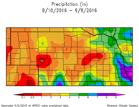
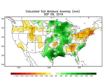
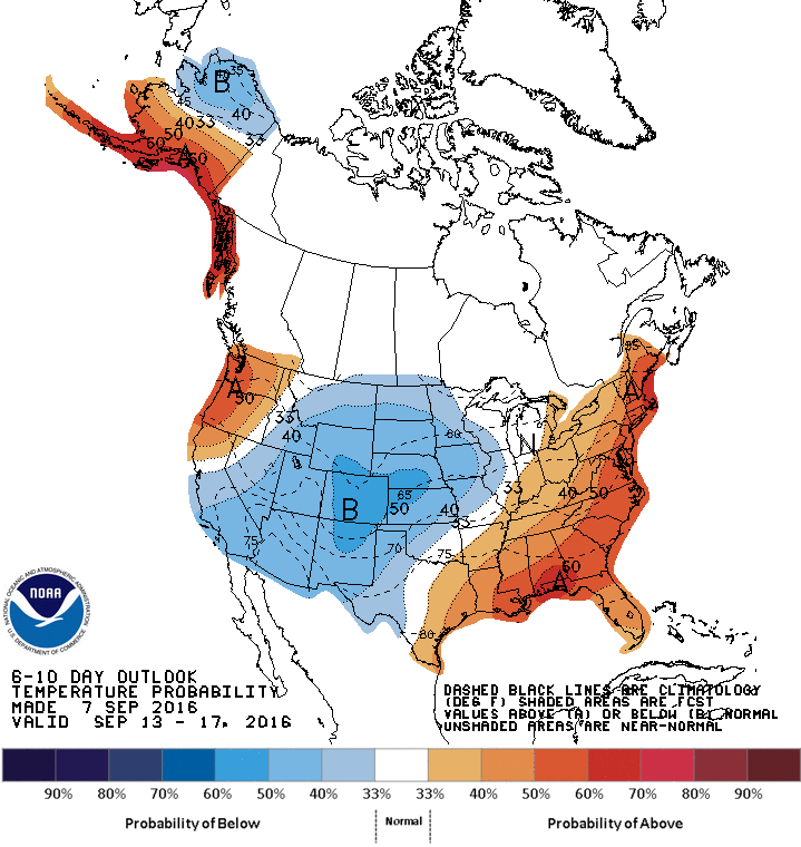
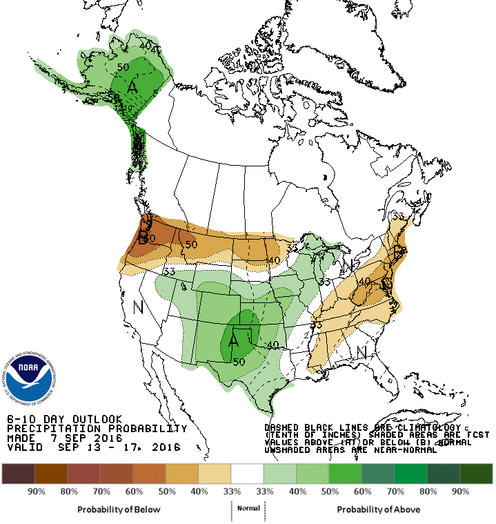
  Weather Recap August, and even the start of September, had some winners and losers when it came to the precipitation pattern. Over the last 30 days, the state ranged from less than a half inch in some locations to more than 10 inches in others. It appears you needed to reside near the Kansas, Missouri, and Iowa borders to receive much precipitation (Figure 1). In general, the central part of the state is the driest, according to the latest SPI (Standardized Precipitation Index). The recent temperature pattern has been uneventful and near normal, on average, for the state. We had some warm days and cool days, but our average temperature has been near normal. The warmest average temperatures were in southeast Nebraska and cooled gradually towards northwest Nebraska. This is typical and is because nighttime lows in the northwest part of the state are much cooler than the southeast, even though daytime highs may be similar. The normal minimum temperature for September in Nebraska is around 55°F in the southeast to the low 40’s in the northwest. Soil moisture and drought are in relatively good shape to wrap up the growing season. The latest soil moisture anomaly map (map above) shows near normal conditions for most of the state with pockets of above normal soil moisture for this time of the year. The Drought Monitor continues to show one spot of severe drought in south central Nebraska with larger areas of abnormally dry conditions in south central and west central Nebraska. Outside of that pocket of unlucky farmers, the rest of the state probably won’t complain about the growing season precipitation. 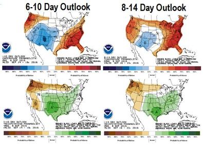 Looking Ahead The main “event” in the forecast will be the continuation of seasonably cool weather. After a few days of relatively warm temperatures, the ridge has eroded and allowed cool air from the north to invade the central part of the country. We will have a fairly warm and dry weekend, but next week will bring in chances for precipitation and high temperatures in the 60s by Tuesday. By the weeks end, temperatures will climb back into the upper 70s and 80s, but we will experience a number of days of below normal temperatures. Precipitation looks to be fairly light next week with the best chances in the southeastern half of Nebraska. Another wave is expected to move through next weekend, which will bring in another chance for precipitation. The 6-10 Day and 8-14 Day outlooks (figure above) from the Climate Prediction Center (CPC) are keeping the below-normal or near-normal temperatures and above normal precipitation for Nebraska for the next 10 to 14 days. The rest of September is shaping up to be fairly turbulent. After months of expecting a warm and dry fall, it appears that September could be just the opposite for Nebraska and most of the northern and central plains. The models have a number of systems coming down from Canada and tracking over the northern plains and through the Great Lakes. Obviously, this is a general statement, but we could see increased precipitation and influxes of cool air following the frontal passages. The southern extent of these systems will determine whether Nebraska is warm/cool or dry/wet. Based off of the recent pattern, it appears we may be in the cool and wet side of the systems. Notice, I didn’t say cold. We are still a little ways off of that. The long-term outlook for the fall season is up in the air, again. The La Niña that was expected this summer, and then this fall, and then this winter has essentially been dismissed. We will have La Niña appearing ocean temperatures, but the strength and coverage area will be minimal, so the atmosphere is not expected to respond as originally thought. Long story short, our best long-term forecasting tool is ENSO (La Niña/El Niño) and we no longer have that. We will be able to use long-term models and current conditions, but the outlooks can then become very “near-sided”. The September through November Outlooks from the CPC are continuing to show increased chances for above normal temperatures over the three month period for the entire U.S. Again, this is most likely based off of the trend of increasing temperatures rather than forecasting models, especially after the U.S. is coming off of it’s 5th warmest summer on record and 3rd warmest January through August. In review, we can expect a nice weekend, but a cool and damp beginning to next week. Another cool down and rain event could move through next weekend and drop temperatures back down after a decent warm up to end the week. The rest of September may see a continuation of this pattern, which won’t help for crop dry-down. It does not look like precipitation will be extremely heavy, so field work can probably continue with only a few delays. Tyler Williams Nebraska Extension Educator in Lancaster County lancaster.unl.edu [email protected] Twitter: @tylerw_unl 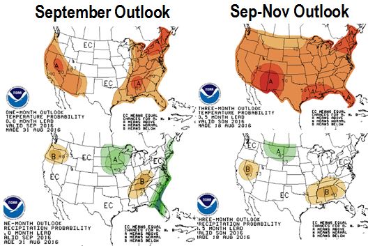 The meteorological fall season started September 1, actual season starts September 22, and the weather says be ready for it now. The temperature forecasts and outlooks are showing a cooling pattern this weekend and into next week that will definitely make it feel like fall.
|
AuthorI study weather and climate impacts on agriculture, climate variability, and using weather and climate information to make better agricultural decisions. Archives
November 2017
|
 RSS Feed
