The Good
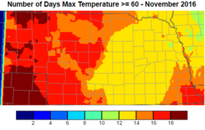
For the third month in a row, abnormally warm temperatures have been the story. The 30-year normal maximum temperature for November ranges from the low 50s in the south to the upper 40s in the north and we surpassed that quite often. The state had 12-20 days in November where the high was above 60°F and some spots had 5-6 days with temperatures greater than 75°F. Monthly lows were 5-8°F (west) to 21-23°F (east). Highs were 82-84°F (central and south) to 72-74°F (northeast and west). Soil temperatures at 4” are in the upper 30s in the east and low 30s in the west. At least we have unfrozen soils and any precip will soak in.
For the third month in a row, abnormally warm temperatures have been the story. The 30-year normal maximum temperature for November ranges from the low 50s in the south to the upper 40s in the north and we surpassed that quite often. The state had 12-20 days in November where the high was above 60°F and some spots had 5-6 days with temperatures greater than 75°F. Monthly lows were 5-8°F (west) to 21-23°F (east). Highs were 82-84°F (central and south) to 72-74°F (northeast and west). Soil temperatures at 4” are in the upper 30s in the east and low 30s in the west. At least we have unfrozen soils and any precip will soak in.
The Bad
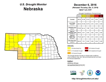
Not a lot in agriculture is dependent on the November weather, so not a lot can go wrong; however, the warm temps have continued to dry out the soil (with minimal precip), increase pest pressure in wheat, delay anhydrous application, and encourage more tillage. Soil moisture continued to decrease for most of the state, especially in the west, and some areas of moderate drought remained. Stripe rust, grasshoppers, and other pests have damaged a decent winter wheat crop due to extended freeze-free period. Soil temperatures recently (last couple weeks) dropped below 50°F for the state in order for anhydrous ammonia applications to be relatively successful. There also was an abundance of field work due to the quick harvest and nice weather. There are many, many benefits to leaving residue and utilizing no-till practices, but this may not seem like a “bad” thing to some.
Not a lot in agriculture is dependent on the November weather, so not a lot can go wrong; however, the warm temps have continued to dry out the soil (with minimal precip), increase pest pressure in wheat, delay anhydrous application, and encourage more tillage. Soil moisture continued to decrease for most of the state, especially in the west, and some areas of moderate drought remained. Stripe rust, grasshoppers, and other pests have damaged a decent winter wheat crop due to extended freeze-free period. Soil temperatures recently (last couple weeks) dropped below 50°F for the state in order for anhydrous ammonia applications to be relatively successful. There also was an abundance of field work due to the quick harvest and nice weather. There are many, many benefits to leaving residue and utilizing no-till practices, but this may not seem like a “bad” thing to some.
The Outlook
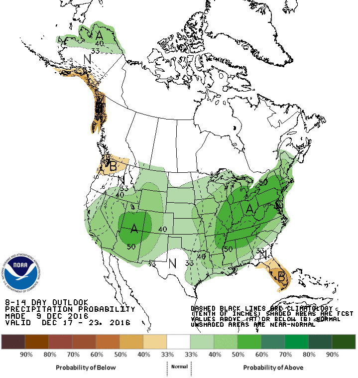
The recent forecasts have only been accurate out to a few days, so this forecast may be about the same, but we do know that our honeymoon of warm temperatures is over for a while. Arctic air has finally made its push down into the northern plains and we will barely get above freezing through the weekend. This big push of cool air diminished our chances for “snow-maggedon” because the high pressure pushed the system south of our region and brought in much drier air. Overall, the next 5-7 days appears to be cool, mostly dry with a relatively uneventful pattern.
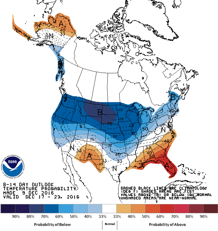
Looking past this weekend, the models are not showing any time of pattern-changing system to move through. Temperatures will be moderate to start next week, but may bottom out again the middle of next week. The models are picking up on another push of arctic air down into the center of the U.S. and we could see very cold temperatures. The 6-10 and 8-14 Day Outlooks from the CPC continue to forecast increased high chances fore below normal temperatures for the northern part of the U.S. The latter part of the forecast period (next weekend and beyond) does show a hint of a potential warming trend; however, the models have been hinting at this for a while and it keeps getting pushed back and I will believe that when I see it. The precipitation is forecasted to be near to above normal for our region with the heaviest moisture in the west and east, but it doesn’t take much moisture to be “normal”.
The extended outlook for the rest of the month and winter, in short, looks cold. La Niña typically brings in colder than normal temps during the winter for the northern plains. Lately, our weather has mimicked La Niña patterns, so we could see this continue IF La Niña does not dissipate. Be looking for big temperature swings the next couple months with below normal precipitation. Winter is here.
Tyler Williams, Nebraska Extension Educator
Cropping Systems and Climate Resiliency
The recent forecasts have only been accurate out to a few days, so this forecast may be about the same, but we do know that our honeymoon of warm temperatures is over for a while. Arctic air has finally made its push down into the northern plains and we will barely get above freezing through the weekend. This big push of cool air diminished our chances for “snow-maggedon” because the high pressure pushed the system south of our region and brought in much drier air. Overall, the next 5-7 days appears to be cool, mostly dry with a relatively uneventful pattern.
Looking past this weekend, the models are not showing any time of pattern-changing system to move through. Temperatures will be moderate to start next week, but may bottom out again the middle of next week. The models are picking up on another push of arctic air down into the center of the U.S. and we could see very cold temperatures. The 6-10 and 8-14 Day Outlooks from the CPC continue to forecast increased high chances fore below normal temperatures for the northern part of the U.S. The latter part of the forecast period (next weekend and beyond) does show a hint of a potential warming trend; however, the models have been hinting at this for a while and it keeps getting pushed back and I will believe that when I see it. The precipitation is forecasted to be near to above normal for our region with the heaviest moisture in the west and east, but it doesn’t take much moisture to be “normal”.
The extended outlook for the rest of the month and winter, in short, looks cold. La Niña typically brings in colder than normal temps during the winter for the northern plains. Lately, our weather has mimicked La Niña patterns, so we could see this continue IF La Niña does not dissipate. Be looking for big temperature swings the next couple months with below normal precipitation. Winter is here.
Tyler Williams, Nebraska Extension Educator
Cropping Systems and Climate Resiliency
 |  |
 RSS Feed
