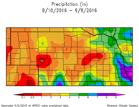
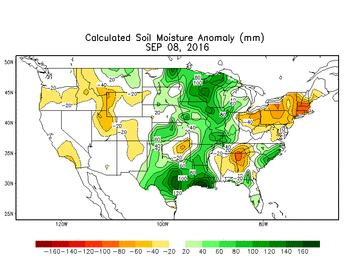
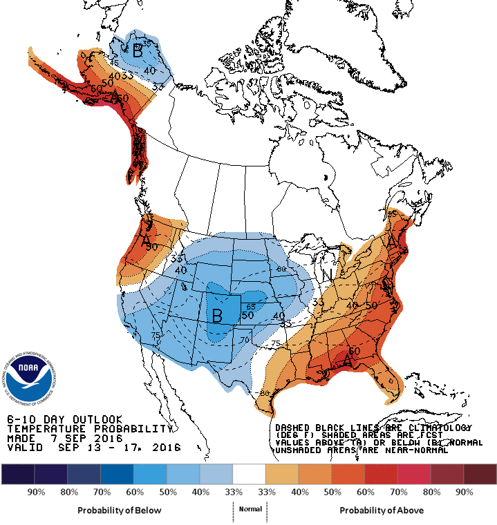
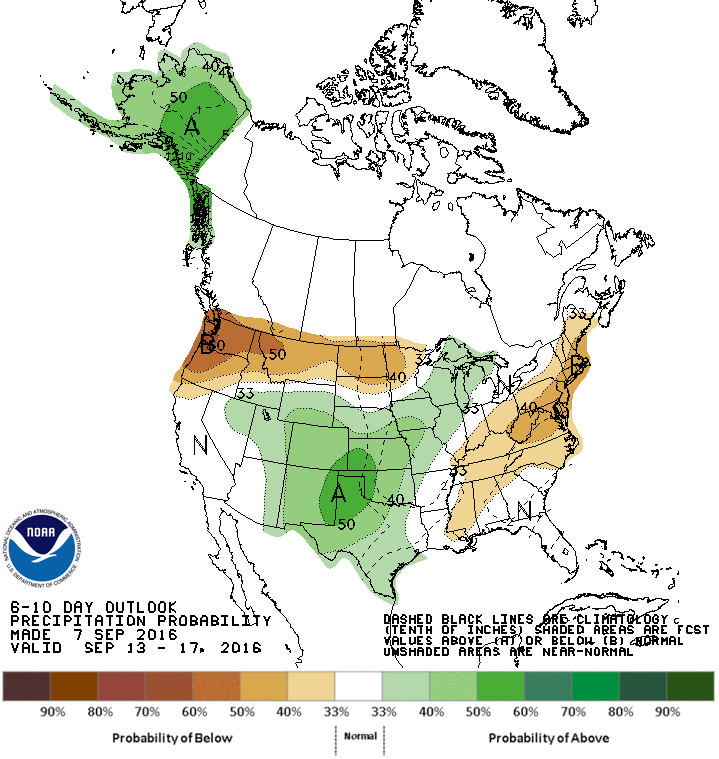
  Weather Recap August, and even the start of September, had some winners and losers when it came to the precipitation pattern. Over the last 30 days, the state ranged from less than a half inch in some locations to more than 10 inches in others. It appears you needed to reside near the Kansas, Missouri, and Iowa borders to receive much precipitation (Figure 1). In general, the central part of the state is the driest, according to the latest SPI (Standardized Precipitation Index). The recent temperature pattern has been uneventful and near normal, on average, for the state. We had some warm days and cool days, but our average temperature has been near normal. The warmest average temperatures were in southeast Nebraska and cooled gradually towards northwest Nebraska. This is typical and is because nighttime lows in the northwest part of the state are much cooler than the southeast, even though daytime highs may be similar. The normal minimum temperature for September in Nebraska is around 55°F in the southeast to the low 40’s in the northwest. Soil moisture and drought are in relatively good shape to wrap up the growing season. The latest soil moisture anomaly map (map above) shows near normal conditions for most of the state with pockets of above normal soil moisture for this time of the year. The Drought Monitor continues to show one spot of severe drought in south central Nebraska with larger areas of abnormally dry conditions in south central and west central Nebraska. Outside of that pocket of unlucky farmers, the rest of the state probably won’t complain about the growing season precipitation. 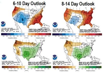 Looking Ahead The main “event” in the forecast will be the continuation of seasonably cool weather. After a few days of relatively warm temperatures, the ridge has eroded and allowed cool air from the north to invade the central part of the country. We will have a fairly warm and dry weekend, but next week will bring in chances for precipitation and high temperatures in the 60s by Tuesday. By the weeks end, temperatures will climb back into the upper 70s and 80s, but we will experience a number of days of below normal temperatures. Precipitation looks to be fairly light next week with the best chances in the southeastern half of Nebraska. Another wave is expected to move through next weekend, which will bring in another chance for precipitation. The 6-10 Day and 8-14 Day outlooks (figure above) from the Climate Prediction Center (CPC) are keeping the below-normal or near-normal temperatures and above normal precipitation for Nebraska for the next 10 to 14 days. The rest of September is shaping up to be fairly turbulent. After months of expecting a warm and dry fall, it appears that September could be just the opposite for Nebraska and most of the northern and central plains. The models have a number of systems coming down from Canada and tracking over the northern plains and through the Great Lakes. Obviously, this is a general statement, but we could see increased precipitation and influxes of cool air following the frontal passages. The southern extent of these systems will determine whether Nebraska is warm/cool or dry/wet. Based off of the recent pattern, it appears we may be in the cool and wet side of the systems. Notice, I didn’t say cold. We are still a little ways off of that. The long-term outlook for the fall season is up in the air, again. The La Niña that was expected this summer, and then this fall, and then this winter has essentially been dismissed. We will have La Niña appearing ocean temperatures, but the strength and coverage area will be minimal, so the atmosphere is not expected to respond as originally thought. Long story short, our best long-term forecasting tool is ENSO (La Niña/El Niño) and we no longer have that. We will be able to use long-term models and current conditions, but the outlooks can then become very “near-sided”. The September through November Outlooks from the CPC are continuing to show increased chances for above normal temperatures over the three month period for the entire U.S. Again, this is most likely based off of the trend of increasing temperatures rather than forecasting models, especially after the U.S. is coming off of it’s 5th warmest summer on record and 3rd warmest January through August. In review, we can expect a nice weekend, but a cool and damp beginning to next week. Another cool down and rain event could move through next weekend and drop temperatures back down after a decent warm up to end the week. The rest of September may see a continuation of this pattern, which won’t help for crop dry-down. It does not look like precipitation will be extremely heavy, so field work can probably continue with only a few delays. Tyler Williams Nebraska Extension Educator in Lancaster County lancaster.unl.edu [email protected] Twitter: @tylerw_unl 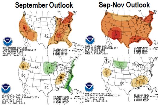 The meteorological fall season started September 1, actual season starts September 22, and the weather says be ready for it now. The temperature forecasts and outlooks are showing a cooling pattern this weekend and into next week that will definitely make it feel like fall.
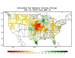
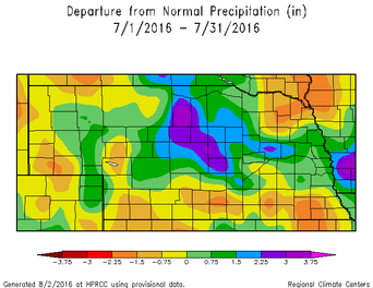 Average July The month of July was, in one word, average; however, as usual, one word doesn't describe the Nebraska weather very well. Some locations received extreme rainfall (6-7”+), or lack thereof (less than 1”), or severe weather (9 tornado, 38 hail, 75 wind reports), but as a state, it was about as average as it comes. During the summer, “average” is usually the average of two extremes anyway and we did it again. Central and East Central Nebraska received much above normal precipitation, but most other locations were near to below normal (Figure 1). Temperatures were variable and were below normal for the “wet” areas and above normal for the “dry” areas. I say that loosely because most of the state is neither too wet or too dry (Disclaimer: we do have some very wet and very dry areas). The latest “Greenness” map (Figure 2), shows most of the state on July 19-25 was slightly “greener” than normal, except for parts of NW Nebraska. For the region, most everyone east of Nebraska received above normal precipitation, except for some areas around the Great Lakes where they remained dry. Temperatures were slightly warmer than normal for the Great Lakes, but variable for the rest of the area. The drought monitor is showing D1-Moderate Drought conditions around Hastings up through Central City, as well as around Scottsbluff through Chadron. These areas have been expanding recently, so is definitely worth monitoring. The 30-Day SPI (Standardized Precipitation Index) is not showing a strong signal for drought conditions, but the 60-Day SPI is showing very dry conditions along the southern tier of Nebraska from Minden through Beatrice. This would suggest July provided near normal conditions for these dry areas, but did not make up for June. 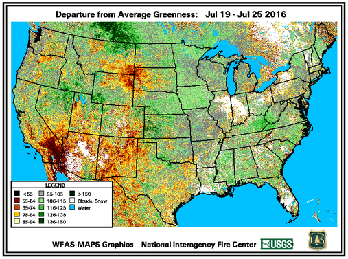 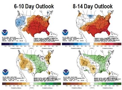 Looking Ahead In general, the forecast is positive from a growing conditions perspective. Temperatures look to be mostly moderate and precipitation is likely. A cold front will move through on Thursday and will cool temperatures considerably from earlier in the week. This will drop high temperatures 10-20°F and we may experience a couple days of highs in the 70s and maybe low 80s. Temperatures will start to climb back up on Sunday and Monday. We will also have multiple opportunities for precipitation with the passage of the front and moderation of the ridge that has been over the middle of the U.S. For the next week or two, temperatures are expected to remain moderate and near normal for this time of year, which can still be quite warm. We will warm back up next week with flow from the southwest and will probably warm from west to east. The models are showing multiple shortwaves move through the northern plains and could keep the very warm temperatures to our south. It will also allow more chances of precipitation over our state. We have been in this pattern of waves moving through the region and it could continue. The 6-10 Day and 8-14 Day Outlooks from the Climate Prediction Center (CPC) are showing similar patterns. They are expecting near to below normal temperatures for most of the western U.S., but Nebraska will be in the transition zone of near or above normal temperatures. This will depend on the amplitude of next weeks ridge, but the models have been fairly poor in predicting temperature trends out past seven days. The northern plains and Midwest, including parts of Nebraska, have increased chances for precipitation the next couple weeks. The one-month outlook (Figure 4) is indicative of continuation of this precipitation trend with increased odds for above normal precipitation for much of Nebraska and the Corn Belt. The long-term outlook for the next few months has been changing with the decreased odds for a strong La Niña. The CPC is showing increased odds for above normal precipitation for the northern plains and a blanket of increased odds for above normal temperatures for the U.S. (Figure 4). This temperature outlook is most likely following the trend of a warmer U.S. over the past year. The expectation of La Niña is getting later in the calendar year and most likely will be a weak La Niña. This is quite a shift considering this past spring many people thought we would quickly transition into a moderate La Niña and could see some growing season impacts. That didn’t happen and the trend is for it to have even less of an impact. We may see some impact this winter, but we will see how it progresses. Tyler Williams Nebraska Extension Educator in Lancaster County lancaster.unl.edu [email protected] Twitter: @tylerw_unl 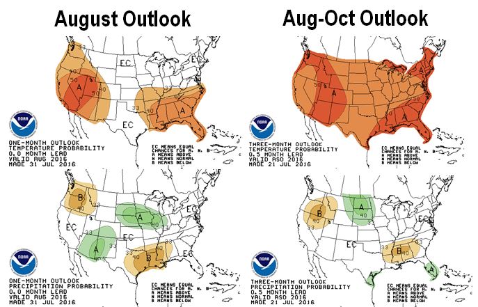 General take-aways: Lincoln: Highs range 80-100F, Lows range 55-75F, Rain 25% of days North Platte: Highs range 80-100F, Lows range 45-70F, Rain 31% of days   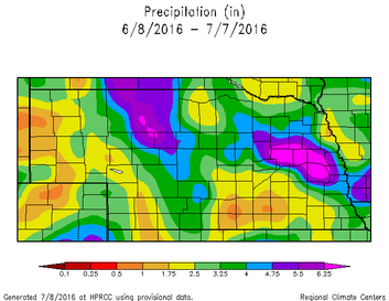 Summer is Here June turned out to be a pattern changing month. Cool, wet conditions prevailed in May and the furnace kicked on for most of June. After a nice cool down over the Independence Day holiday, temperatures have ramped right back up. Precipitation over the last 30 days has been primarily over the central sandhills and east central Nebraska (right). These are the areas where thunderstorms have been tracking and over-lapping, which is about the only way to get precipitation in June and July. Other than that, the state has been primarily dry; however, some recent rain has alleviated some pressure. The driest areas seem to be in the Panhandle and south central Nebraska from about Minden to York. Although the precipitation was highly variable, most of this area received less than two inches over the last 30 days, which is 2-4 inches below normal. 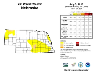 The above normal temperatures lately sped up the drying process. 30-Day temperature departures are 4-8°F above normal and that has brought some color to Nebraska in the last few Drought Monitor (left) maps. We now have an area of moderate drought in far northwest Nebraska near Chadron and between Kearney and Grand Island . This map doesn't account for the rain that fell after Tuesday, June 5. The crops are also beginning to use a substantial amount of moisture. Potential ET values have been around 0.2-0.25” per day, so corn at the 14 leaf stage will be using nearly 0.2-0.25” of water per day. This amount of water use will use up soil moisture quickly, so it is important to monitor soil moisture status closely over the next few weeks. 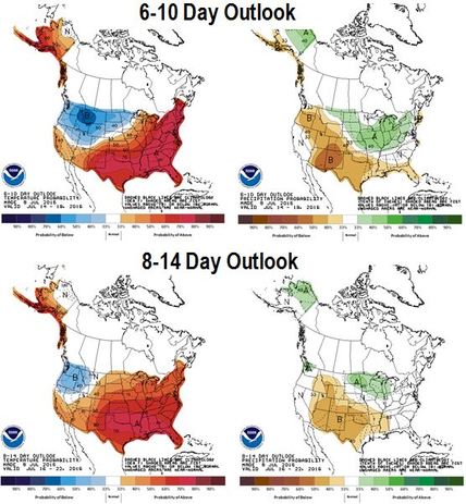 Looking Ahead
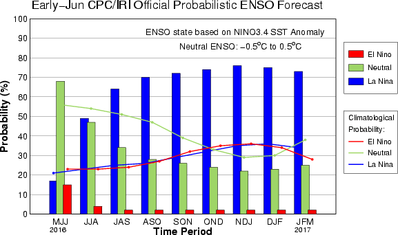
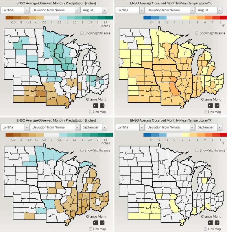
The forecast is fairly uneventful and very “summer-like” for the next few days. Temperatures over the weekend and into next week will by in the upper 80s and low 90s. Precipitation chances will be small and limited primarily to pop-up thunderstorms with the best chances on Sunday night into Monday. It will be a good weekend to head to the lake. As we get into next week, eastern Nebraska has the best chances for precipitation on Monday through Wednesday, as the west looks to remain relatively dry with a few chances for isolated thunderstorms. A moderate cool down looks to arrive the middle of next week and temperatures will stay in the 80s for a few days. By next weekend, the models have temperatures starting to warm back up as a ridge of high pressure begins to build back in. If this ridge of high pressure does what the models are predicting, we could have very warm and very dry weather for the third week of July. The cool down next week will be very much appreciated and will give us some opportunities for moisture. Let’s just hope we don’t miss them. The 6-10 Day (July 14-18) and 8-14 Day (July 16-22) Outlooks (right) from the Climate Prediction Center are showing increased chances for above normal temperatures for the central and eastern parts of the U.S. The best chances for above normal precipitation are in the northern and eastern U.S., which does include parts of Nebraska. This pattern is due to the location of the jet stream and this will be the area where shortwave disturbances will travel and provide the best chances for precipitation. Right now, the odds are a lot higher for this area to remain east of Nebraska, possibly providing cooler temperatures and moisture for the “I” states during corn pollination! Western Nebraska looks to be the area most vulnerable to the hot and dry weather, with better odds as you move east. This is still a week or two out, so a lot can change. The models are not showing a lot of consistency in the location of this pattern, but it is probably best to not get behind on irrigation over the next 10 days to two weeks. With corn pollination upon us, it is not a good time to play catch up. Looking past the next few weeks is a coin flip right now. The La Niña that was building in fast and furious in May has slowed down considerably. We are still projected to have a La Niña later this fall and early winter, but seeing any impact before that may be quite limited. There is still a lot of warm water in the higher latitudes of the Pacific Ocean. This lack of La Niña signal limits the predictability in the three-month outlook . In summary, we are nearing the climatologically warmest week for Nebraska, so anything under 90°F is a blessing. It looks like the next week or so will have moderate temperatures with a few opportunities for precipitation. The following one or two weeks may see high pressure build in and turn hot and dry, especially for the western half of Nebraska. Let’s hope that ridge does not get as strong or stick around as long as the models currently predict. Tyler Williams Nebraska Extension Educator in Lancaster County lancaster.unl.edu [email protected] Twitter: @tylerw_unl As you have heard, we are quickly transitioning from a strong El Niño to a La Niña. This plays a large role in global weather patterns, so many forecasters (and farmers) pay attention to this phenomenon. How this happens is quite interesting and is explained very well in this ENSO Blog Post from Climate.gov. If knowing how La Niña and El Niño form, I highly encourage reading that blog post. If that doesn't interest you, the graph and map below may be all you want to know.
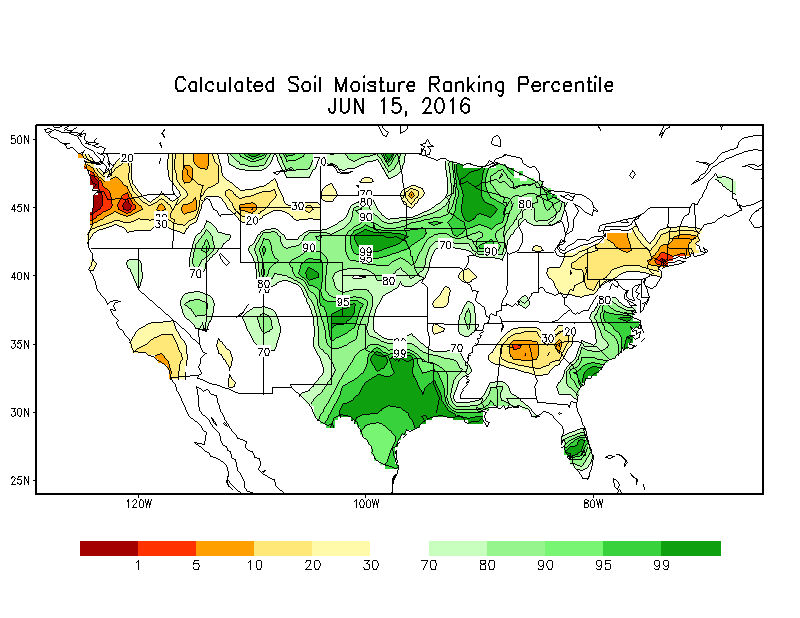
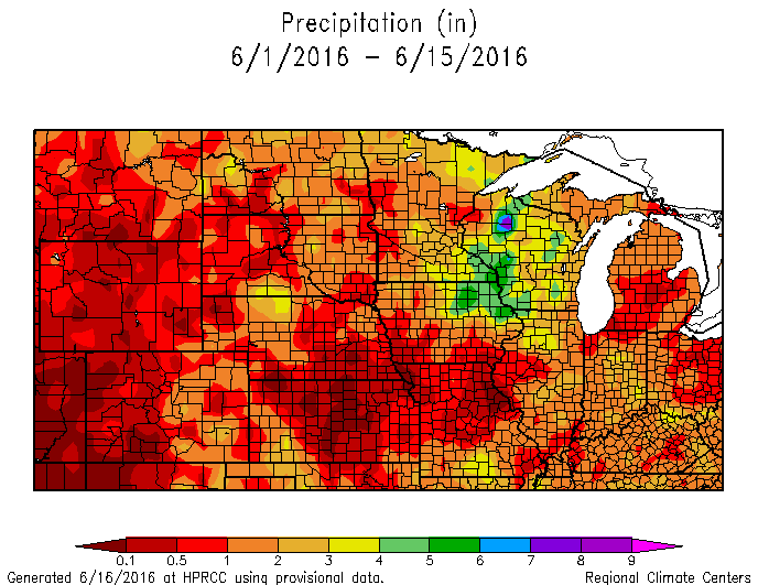
 When it is hot and dry, water evaporates. This is a simple concept and is a very easy explanation as to why soil moisture values have dropped significantly over Nebraska, Kansas, and Missouri over the last couple weeks. Precipitation has been near zero for a large portion of the area, with some exceptions for the areas that were able to see some rain from localized thunderstorms. Profile soil moisture values are still above or near normal for all of Nebraska (see below); however, it has been the rapid surface drying and quick degradation of soil moisture that has a lot of farmers and ranchers concerned, and rightfully so.
The forecast for temperatures is not positive for the foreseeable future (see below), especially if we remain dry. 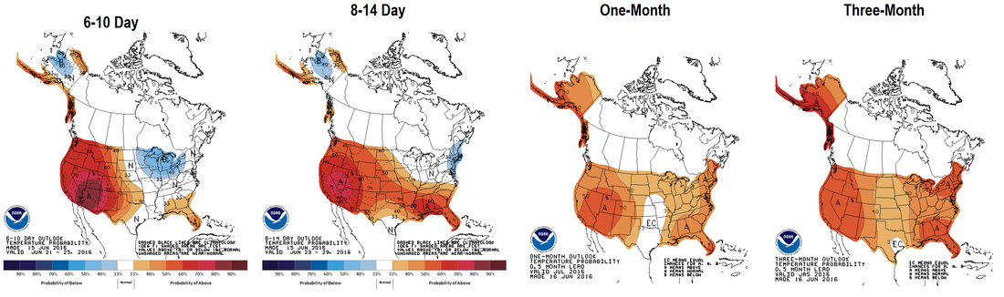  Wet & Cool to Hot & Dry The weather in Nebraska has slowly transitioned from wet (very wet for some) and relatively cool to dry and warm. May ended up being cooler (1-3°F ) and wetter (0-3 inches) than normal (Figure 1). Portions of the Panhandle ended up with below normal precipitation and northeast Nebraska was slightly warmer than normal, but overall, it was cool and wet. Then June arrived. The first week of the month was dry for almost everyone except a small area in the east central part of the state. We have also ramped up the temperatures and we have been steadily in the 90s for a few days. This will rapidly dry out the surface, especially for fields, gardens, etc. that do not have any residue cover. Residue will keep some of that moisture in your soil and will moderate soil temperatures. Those with surface residue will be thankful they have it this week. 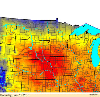 Livestock Heat Stress Forecast for the Central Plains on Saturday, June 11. Map from USDA-ARS - www.ars.usda.gov/npa/marc/heatstress Livestock Heat Stress Forecast for the Central Plains on Saturday, June 11. Map from USDA-ARS - www.ars.usda.gov/npa/marc/heatstress The Heat Is On With temperatures rising for the first time this season, it is always good to touch on some information to help protect livestock. The heat stress on livestock, and specifically cattle, is a combination of both heat and humidity. Handling cattle early in the mornings before temperatures get too high is always recommended and is a good practice during the summer months. The animal’s core temperature peaks approximately two hours after the environmental temperature peaks and takes four to six hours to lower back to normal temperature. Consider shade for the animals, working smaller groups at a time, adequate air flow, and minimizing stress on the animal to reduce losses due to heat stress. The USDA-ARS provides a livestock heat stress map (Figure 2) to help plan for these events. The heat will have an impact on water resources, but the current state of soil moisture and stream flows in Nebraska should limit any severe impact from the upcoming heat wave. Many rivers are at, near or above capacity in the state and the 60-day Standardized Precipitation Index (SPI) is not showing negative values at this time. The 30-day SPI is showing some negative values in the Panhandle, but that area is small, for now. We should remain drought free for a while with the potential for the “Abnormally Dry” category to move into NW Nebraska in the coming weeks. 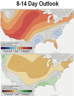 Looking Ahead The forecast headline is no doubt the warm temperatures. We have heard about this for sometime and it is finally here. The high temperatures and mostly dry and windy conditions will remain for most of Nebraska through the weekend. There is a strong ridge over the middle of the country and that is allowing much above normal temperatures to settle in from Texas to Canada. Then Sunday night and Monday rolls around and things get interesting. A week trough will move through Nebraska Sunday night and bring chances of precipitation. With high dewpoints, the precipitation could be heavy, but probably not widespread. The bigger system moves through Monday and Tuesday, which will bring in more chances for precipitation. Currently, the models have this system as a cut-off low over the central plains, which could create some unusual weather for us. I think the potential for severe weather, heavy rain, and the chance of totally missing out on any precipitation are all viable options at this point. Right now the target for the highest precipitation amounts (and strong storms) is for the central part of the state on Monday and Tuesday. Either way, precipitation does look likely for a large portion of the state, but we won’t know much about the location or amounts until after the event. The timing of the exit of the mid-week system will determine the weather for the rest of next week. Models are showing a fairly quick return to a warm and dry weather pattern, however, that cut-off low could linger around longer than expected, especially in eastern Nebraska, and could keep some clouds around and moderate high temperatures. The 8-14 Day (June 18-24) Outlook from the Climate Prediction Center (Figure) is showing increased chances for above normal temperatures and below normal precipitation for most of the Plains and Midwest. We will see what sort of precipitation we receive out of this next system, but another couple weeks of warm and dry weather could create some surface drying issues, especially in western Nebraska. My hunch is that temperatures may be above normal, but shouldn’t be as extreme as what we will experience this weekend. The models are not as amplified and should hopefully moderate the very high temperatures and decrease overall wind speeds. 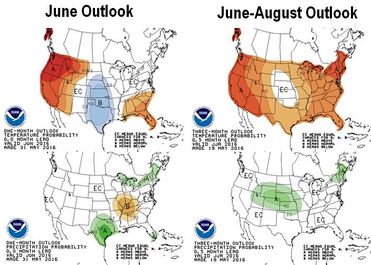 Looking out long-term, I truly don’t have a handle on the next 30-45 days. With La Nina making it’s arrival later this summer or early fall, we may see the long-term outlooks start to pickup on typical La Nina conditions, which could bring warm and dry weather to the Midwest. The current June and June through August Outlooks from the CPC (Figure) show enhanced chances for below normal temperatures for us in June and above normal precipitation for June through August. Again, these maps are based on a probability of conditions compared to normal and I think will change quite a bit as they are updated next week. Be looking for a response to that release next week.
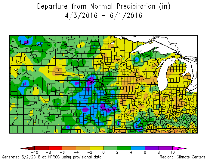
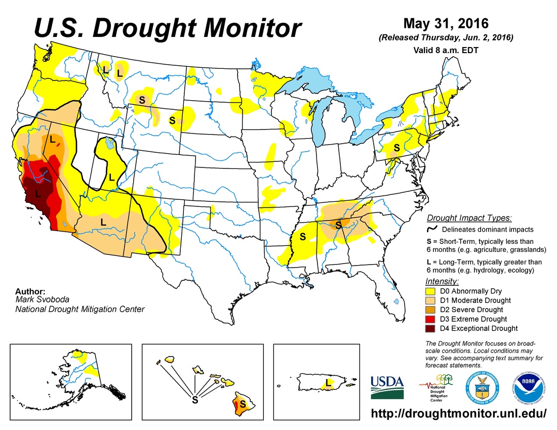
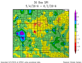
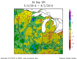
Stay cool…. Tyler Williams Nebraska Extension Educator in Lancaster County lancaster.unl.edu [email protected] Twitter: @tylerw_unl Nebraska and Kansas are the exception this year when it comes to wet conditions for the start of the growing season. Most of Nebraska has received adequate to excessive rainfall this spring, which has caused some problems, but has also provided valuable moisture for crops and pastures. Most of Nebraska is 2-4 inches above normal since the start of April and remains drought free in the latest Drought Monitor. The area to watch for early season dryness (at least in the Corn Belt) is central/eastern Iowa through western Ohio. A lot of that region is 2-4 inches below normal since early April and 30-Day SPI values are indicating early drought conditions. The drought monitor has not picked up on much of this dryness because soil moisture values are not indicating much stress. Conditions in this region are not severe, but are worth watching when it comes to marketing grain.
|
AuthorI study weather and climate impacts on agriculture, climate variability, and using weather and climate information to make better agricultural decisions. Archives
November 2017
|
 RSS Feed
