The Good
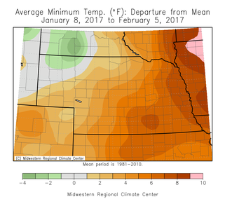
Recently, temperatures have been relatively mild after a roller coaster ride the first part of winter. Minimum temps over the last 30 days have been near average (NW) to 6-8°F above average (SE) and high temps have been near average (NW) to 2-4°F above average (SE). This has allowed soil temps at the 4” depth to maintain near the freezing mark for most of Nebraska after a very cold end to December and start to January. Maximum temps reached the mid 60s in the south to the upper 40s in the northwest with a range of temperatures in between. The minimum temps ranged from –3 to –5°F in the east to –25 to –30°F in the west. Our climatological coldest day of the year is the second week of January, so things are looking up from here.
Recently, temperatures have been relatively mild after a roller coaster ride the first part of winter. Minimum temps over the last 30 days have been near average (NW) to 6-8°F above average (SE) and high temps have been near average (NW) to 2-4°F above average (SE). This has allowed soil temps at the 4” depth to maintain near the freezing mark for most of Nebraska after a very cold end to December and start to January. Maximum temps reached the mid 60s in the south to the upper 40s in the northwest with a range of temperatures in between. The minimum temps ranged from –3 to –5°F in the east to –25 to –30°F in the west. Our climatological coldest day of the year is the second week of January, so things are looking up from here.
The Bad
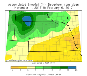
The lack of snowfall for many people may be seen as a positive; however, snow cover provides some agronomic benefits. Even though we have had near normal precipitation this winter, much of that fell as rain, and the snow we did receive melted quickly. Snow cover acts as insulation for the soil ecosystem, and over-wintering crops such as wheat rely on that protective layer during cold out-breaks. Northwest Nebraska did get more than their fare share of snow and received upwards of 30-40” since Nov. 1, which is 15-20” above average. Southeast Nebraska is 10-15” below average for the season with only a few inches of total snowfall. Even with the snow in NW Nebraska, almost the entire state is snow-free as of Feb. 6. January ended up having above normal precipitation, but was not in the form of snow for most areas.
The lack of snowfall for many people may be seen as a positive; however, snow cover provides some agronomic benefits. Even though we have had near normal precipitation this winter, much of that fell as rain, and the snow we did receive melted quickly. Snow cover acts as insulation for the soil ecosystem, and over-wintering crops such as wheat rely on that protective layer during cold out-breaks. Northwest Nebraska did get more than their fare share of snow and received upwards of 30-40” since Nov. 1, which is 15-20” above average. Southeast Nebraska is 10-15” below average for the season with only a few inches of total snowfall. Even with the snow in NW Nebraska, almost the entire state is snow-free as of Feb. 6. January ended up having above normal precipitation, but was not in the form of snow for most areas.
The Outlook
The forecast for the next couple weeks generally looks warm. A system will move through tonight and tomorrow, which will bring in some snow and a cool down. Temperatures will rebound by the end of the week, possibly into the 50s and 60s; however, the amount of snow cover will make a difference in how quickly we rebound and how warm we will get. Portions of western and northern Nebraska are expected to get accumulating snow, so this will keep air temperatures cooler than if we would have bare ground. A strong ridge will build in and push the northern jet stream far to the north and east after this system moves through allowing us to warm up. Precipitation looks minimal (after tonight) for the next week. A cutoff low is expected to form over the desert southwest early next week and slowly trek across the southern plains It’s path will impact our temps and precipitation chances.
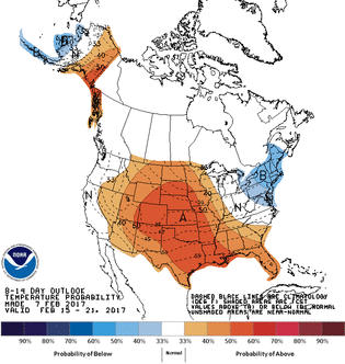
For the extended outlook, it appears we are setting into our late winter pattern with a ridge in the western U.S. and a trough in the eastern U.S. This pattern typically brings in cooler temperatures for eastern Nebraska and warmer temps for the western portions. The location of the jet stream will determine how cold or how warm, but you can still expect that temperature gradient from east to west. The Climate Prediction Center outlooks for February 12-20th have much of the U.S. with increased odds for above normal temperatures, with the highest confidence over the central plains. This pattern aligns with the CPC’s February outlook of higher chances for above normal temperatures. The best odds for precipitation remain on the coasts.
The long-term outlook for the next few months is still quite uncertain for Nebraska. The current La Nina is expected to diminish, but the cool water in the northern Pacific may still play a role in the upcoming weather pattern. It has certainly played a role in the precipitation pattern for California the last couple months.
Tyler Williams, Nebraska Extension Educator
Cropping Systems and Climate Resiliency
[email protected]
The forecast for the next couple weeks generally looks warm. A system will move through tonight and tomorrow, which will bring in some snow and a cool down. Temperatures will rebound by the end of the week, possibly into the 50s and 60s; however, the amount of snow cover will make a difference in how quickly we rebound and how warm we will get. Portions of western and northern Nebraska are expected to get accumulating snow, so this will keep air temperatures cooler than if we would have bare ground. A strong ridge will build in and push the northern jet stream far to the north and east after this system moves through allowing us to warm up. Precipitation looks minimal (after tonight) for the next week. A cutoff low is expected to form over the desert southwest early next week and slowly trek across the southern plains It’s path will impact our temps and precipitation chances.
For the extended outlook, it appears we are setting into our late winter pattern with a ridge in the western U.S. and a trough in the eastern U.S. This pattern typically brings in cooler temperatures for eastern Nebraska and warmer temps for the western portions. The location of the jet stream will determine how cold or how warm, but you can still expect that temperature gradient from east to west. The Climate Prediction Center outlooks for February 12-20th have much of the U.S. with increased odds for above normal temperatures, with the highest confidence over the central plains. This pattern aligns with the CPC’s February outlook of higher chances for above normal temperatures. The best odds for precipitation remain on the coasts.
The long-term outlook for the next few months is still quite uncertain for Nebraska. The current La Nina is expected to diminish, but the cool water in the northern Pacific may still play a role in the upcoming weather pattern. It has certainly played a role in the precipitation pattern for California the last couple months.
Tyler Williams, Nebraska Extension Educator
Cropping Systems and Climate Resiliency
[email protected]
 RSS Feed
