|
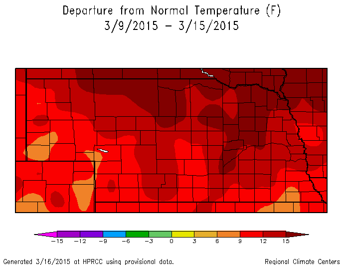
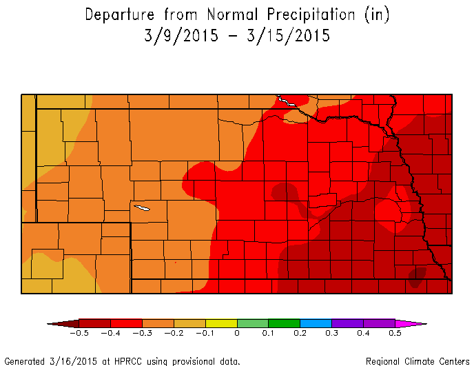
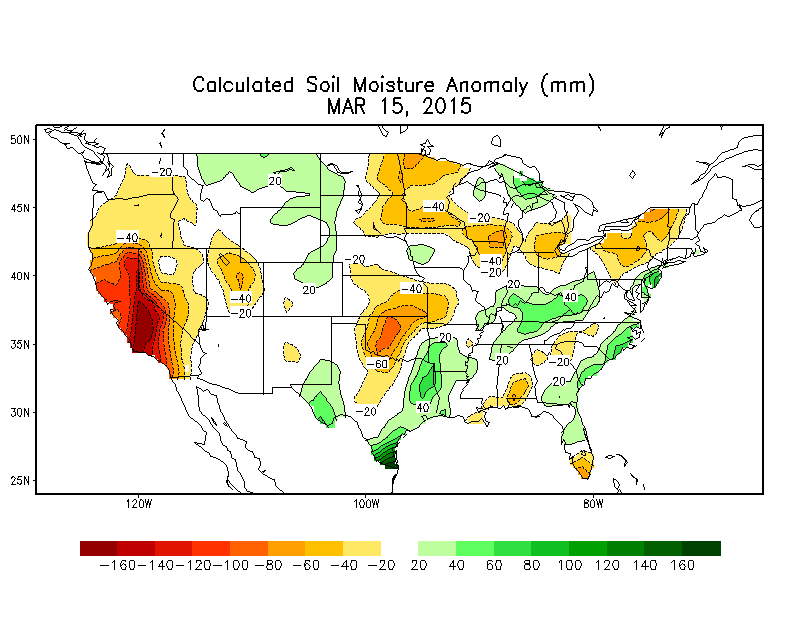
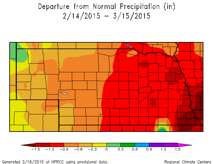
Below is a map story that pretty much sums up the weather over the past seven to ten days in Nebraska. Warm, windy, and dry conditions have warmed up the soils and have used up some valuable soil moisture. It is never to early to start praying for rain.
0 Comments
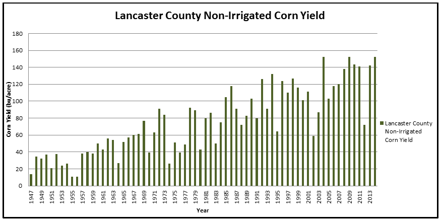
The yield data from USDA/NASS for 2014 was recently released and Lancaster County had the highest non-irrigated average corn yield in the available data set at 152.5 bushels per acre. The yield data for non-irrigated corn goes back to 1947 for Lancaster County and the county average non-irrigated corn yield hit 152 bu/acre in 2004 and 2009. Irrigated corn yield was 191.4 bu/acre, which was lower than 2009 (208 bu/ac), 2004 (193 bu/ac), and 2011 (192.3 bu/ac). Corn yield for all corn grain acres in Lancaster County was 155.7 bu/acre, which was second only to 2009 (156.7 bu/ac), with records for all corn grain yield dating back to 1910.
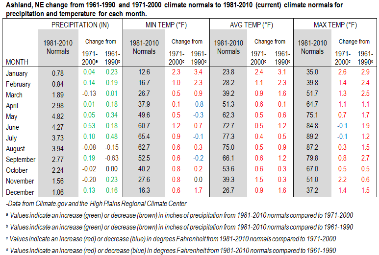
For Cass County, all corn grain yield for 2014 was 170.2 bu/ac, which was second highest yield behind 2009 (176 bu/ac). Otoe County all corn grain yield was 158.8 bu/acre in 2014, which was third most behind 2009 (166 bu/ac) and 2004 (163 bu/ac). More information on 2014 data can be found here. The graph below shows a comparison of the 1981-2010 (current) climate normals to the 1971-2000 and 1961-1990 climate normals. Climate normals are three-decade averages for temperature and precipitation. The data below show an overall warming trend, especially in the winter months and a trend towards more precipitation in the late spring/early summer. It is not uncommon for climate normals to change, but the trend is something worth watching. This current trend leads to an early warm-up in the spring and increased early season evapotranspiration. An increase in precipitation can make up for the increased demand, as long as the precipitation is timely and does not come in one or two events. This increases the need for good soil structure and infiltration to capture all of the moisture, but still have adequate soil structure for timely field operations.
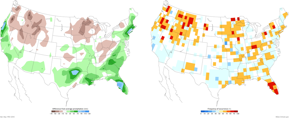
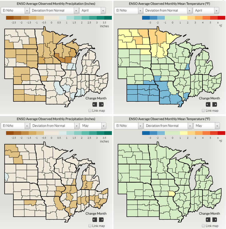
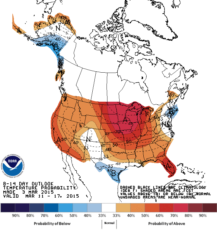
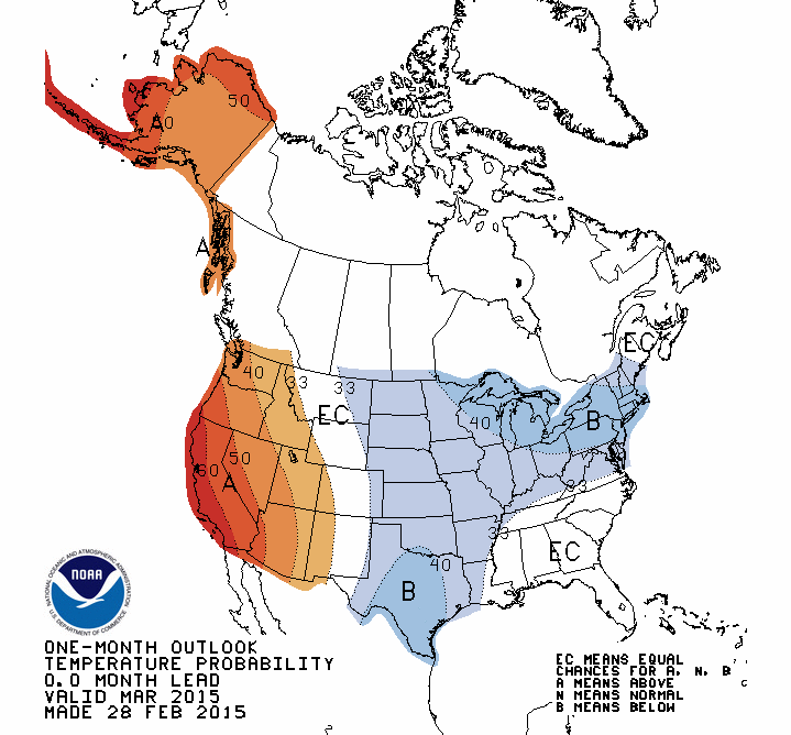
After months of being in an El Nino Watch, the NOAA CPC/IRI issues an El Nino advisory. Conditions have been borderline for an El Nino since last summer, but actual weather conditions did not align to typical El Nino patterns, but some of those features are now taking place. The typical El Nino impacts are weak in the U.S. during the spring, thus forecasts will not increase in confidence. The map below shows the precipitation pattern in the U.S. during an El Nino from March to May and the confidence associated with that pattern. As you can see from the map, there is not much of a signal for precipitation for Nebraska for the three month period. The four maps at the bottom show the deviations from normal for precipitation and temperature during an El Nino for April and May. These maps do show a slight signal for cooler and drier conditions for April and a cooler May, as compared to the 1981-2010 climate normals. View the entire story from NOAA here. The temperature outlook for the next couple weeks is very promising for above normal temperatures. After a very cold last few weeks for many in Nebraska and eastward, this warm weather will be welcome and needed. The one-month outlook still has central and northeast U.S. in the area of increased chances for below normal temperatures. The very cold temperatures over the last few days and the rest of this week look to "even out" the warmth expected next week as far as an average temperature through the firs half of March. This would mean they are predicting enhanced odds for below normal temperatures the final two weeks of March, although the probabilities are quite low for the central and northern plains. Models are suggesting a return to the pattern we saw in late February/early March in week 3. This pattern had the cool air centered over the Great Lakes, which impacted most areas east of the Rockies.
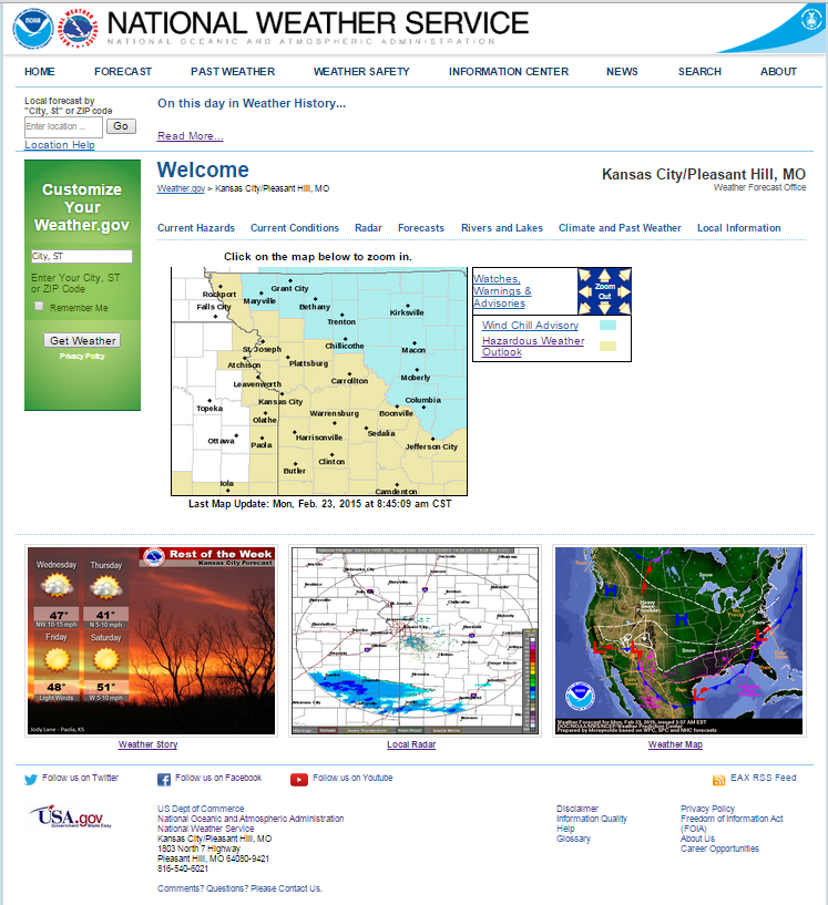
The National Weather Service will be changing their website for some offices in the Central Region, which includes all of the Nebraska offices. Here is a statement from the NWS..... "On or shortly after, Monday, March 30, 2015, all Central Region (CR) NWS Weather Forecast Offices (WFOs), River Forecast Centers (RFCs) and Center Weather Service Units (CWSUs) will migrate to a new layout on the front page of their web home pages. This is in response to a required web infrastructure consolidation that will occur by the end of 2015. The change will also provide office to office consistency because the layout of the home page will be set across the region and eventually across the nation."
|
AuthorI study weather and climate impacts on agriculture, climate variability, and using weather and climate information to make better agricultural decisions. Archives
November 2017
|
| Ag Climate Nebraska |
|
 RSS Feed
