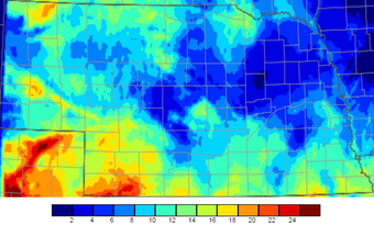
 Number of days above 90°F in August and September
 The temperature pattern over the last 30-60 days has been quite favorable for Nebraska. We had some days that reached the upper 90s, but, overall, the temperature pattern has been near to slightly above normal for most of the state. September started with cool temperatures, but the last week or two has yielded some of the best weather Nebraska has to offer.
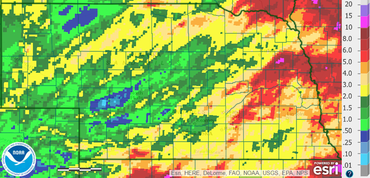
 Radar estimated precipitation for September 2016
 After a rather wet growing season for Nebraska (except for a few locations), we have recently turned dry. Even though many of the crops are mature, late-planted and long-season crops were still using moisture over the last few weeks. Over the last 30 days, portions of central and northwest Nebraska were the driest with less than a half of an inch of precipitation, with a few bands of higher amounts. In general, the state dried out significantly west of Grand Island. This may shorten the grazing season on some pastures and may have aided in early senescence in dryland fields.

Temperatures will gradually cool down the rest of this week and have multiple chances for precipitation. The coldest day will be Thursday and best chance for frost is Friday and Saturday morning. It looks like a VERY good chance of sub 32°F temps for the western half of the state with mid 20s in the far west. The big weather system will slide east through the weekend and we will begin to warm up and dry out. The weather will remain relatively quiet and uneventful most of next week, so should have another long streak of good harvest weather. Temperatures will be warm during the day and cool off during the night, so get used to running your heater and A/C in the same day.
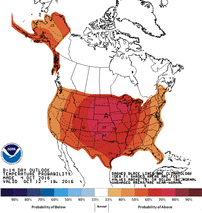
Looking further out, we may settle into a pattern of these deep systems moving through every one to two weeks or so, and each one will bring in cooler temperatures than the previous. The Climate Prediction Center (CPC) is forecasting generally above normal temperatures for Nebraska for October 10-18, as well as their October outlook that gives us slightly higher odds for above normal temperatures. Precipitation is a little less confident and will most likely be near to below normal for the rest of the month, depending on the speed of some of the upcoming frontal passages. There seems to be some confidence that we will not see a big wash-out over the next couple weeks.
La Niña is becoming less of a factor, thus it is not discussed and the winter forecast is a coin toss for Nebraska.
Tyler Williams, Nebraska Extension Educator
Cropping Systems and Climate Resiliency
[email protected], agclimatenebraska.weebly.com

 RSS Feed
