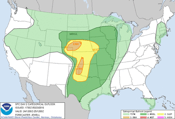
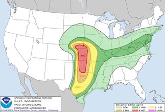
Here is the latest SPC severe weather risk for Tuesday, May 24.
 |  |
| Ag Climate Nebraska |
|
|
|
Here is the latest SPC severe weather risk for Tuesday, May 24.
0 Comments
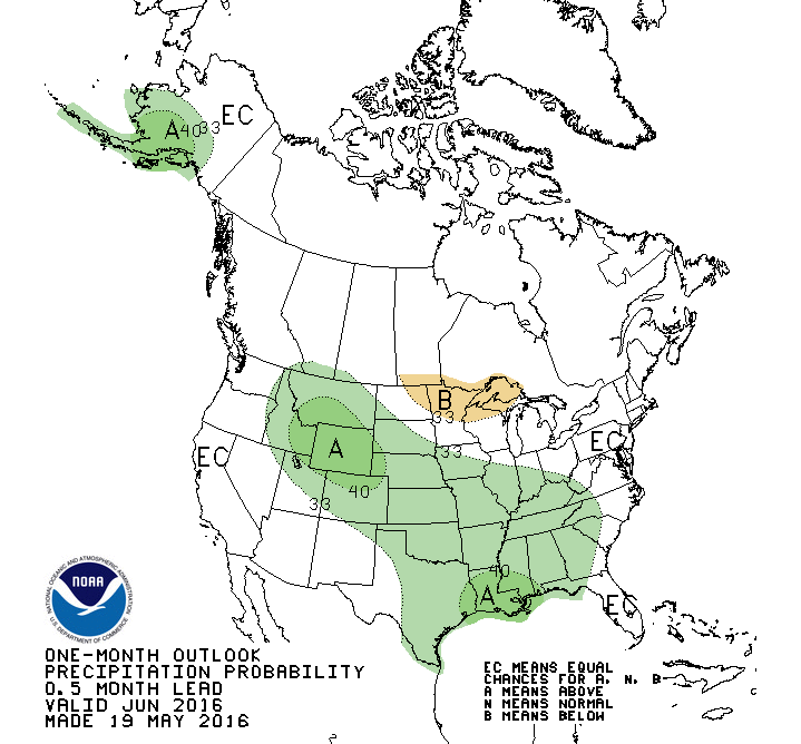
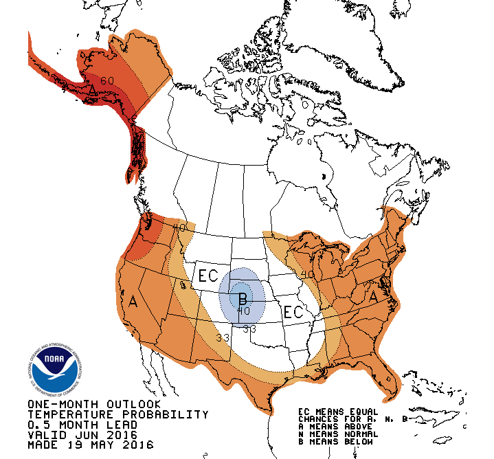
The Climate Prediction Center release the One-Month and Three Month Outlooks, with some interesting features for Nebraska and the Central U.S. There are increased odds for below normal temperature and above normal precipitation for Nebraska. This would suggest the expectation for the recent weather pattern to continue into June. We have been seeing a number of storm systems track across the central U.S. and has kept us wet and relatively cool. Although individual storms may veer off this path, there does seem to be some confidence that the middle part of the country could expect to see continued delays in planting, especially with already wet soils. This region is also very wet and this will decrease our overall temperatures.
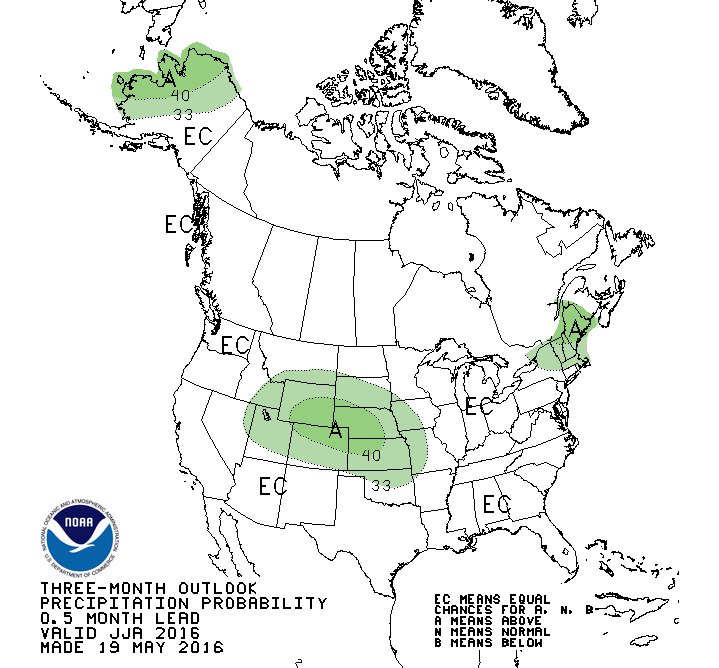
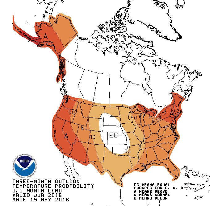
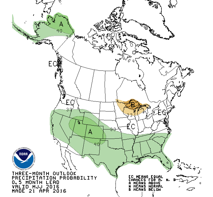
The Three-Month Outlooks have also picked up on this pattern with above normal precipitation expected for the Central U.S. This signal was not evident in last months outlook for the June, July, August time frame. The temperature outlook also reflects this precipitation pattern with equal chances for above or below normal temperatures, which was in the area with increased odds for above normal temperatures last month. The La Nina does not seem to be playing a role in the outlooks for June-August; however, it does seem to show up in the August-October outlooks. Notice the removal of the areas for below normal precipitation in the Great Lakes and eastern Corn Belt.
What does this mean??? An expectation of our current pattern continuing over the next 20-30 days would keep the June temp below normal and precip above normal. This could be enough to sway the three-month outlooks that are floating around the "Equal Chances" categories for July and August due to the unknowns with the transition to La Nina. So, one cool and wet month could have a big impact on a three-month average, if the other two months are average. I don't think we are seeing a huge pattern shift for the summer, but it does look we may stay wet for a while. It is important to remember that most of our summer precipitation is from convective events (thunderstorms) and we all know how "spotty" these events can be. It is always very easy to miss out on these timely events and encounter localized drought stress during rapid vegetation growth.
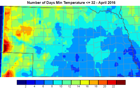
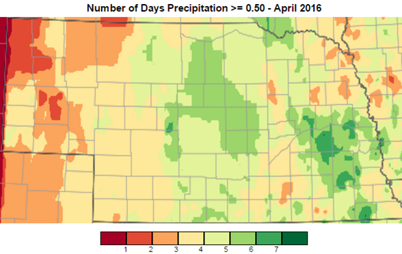
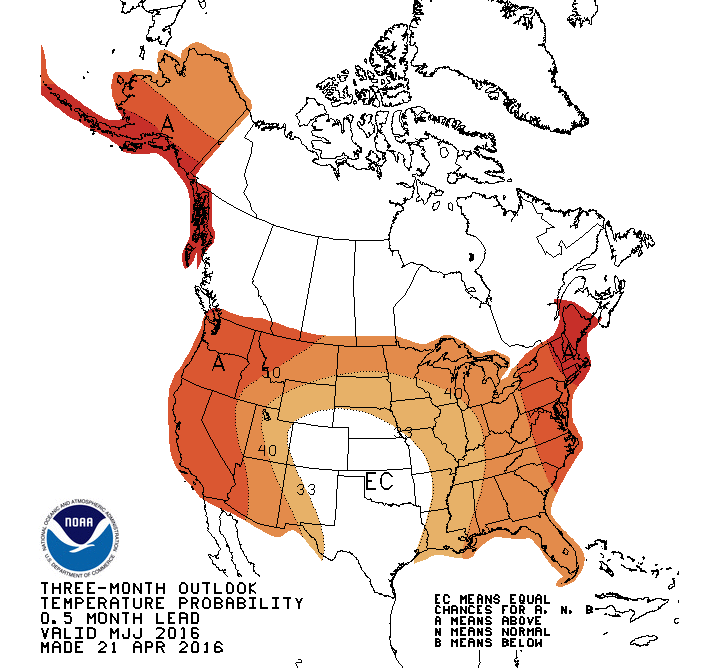
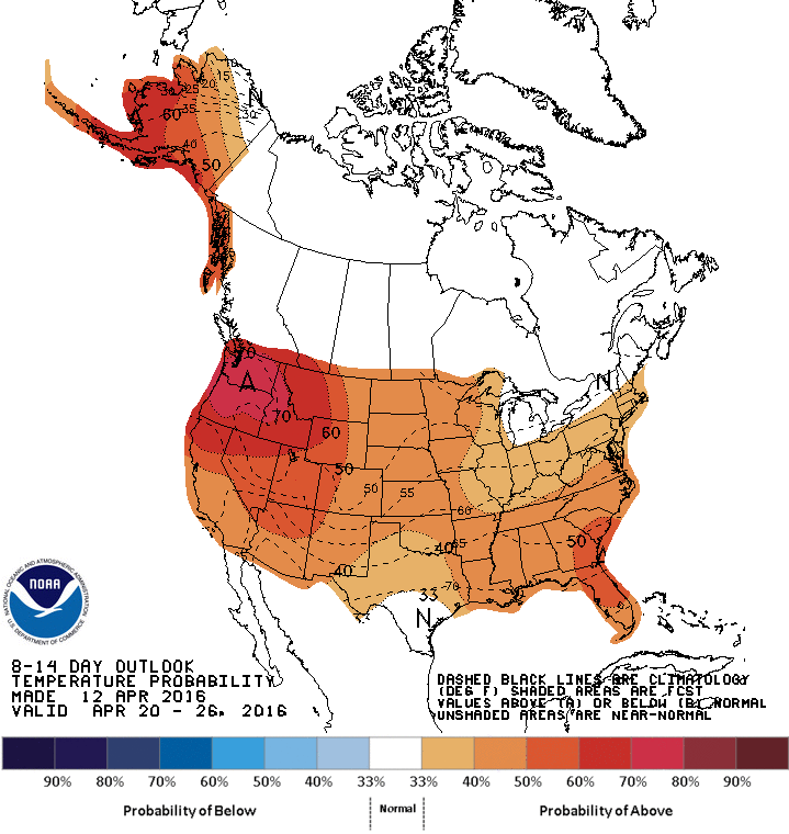
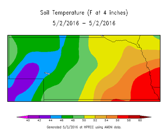 April Had it All Mother nature brought everything it had to Nebraskans this past month. Record rainfall in the central part of the state, snow in the west, and cool, damp weather to end the month. April temperatures ranged from a high of 85°F in Lincoln and Omaha and lows in the teens in the panhandle and northern Nebraska. “Unofficially”, the Ellsworth COOP station in Sheridan County, reported 21.5” of snow and Bushnell 15S COOP station in Kimball County recorded 24 days where the temperature dropped below 32°F. Planting conditions the first week of April were great; however, that was too early for most producers due to the risk of frost and some cold soils. The next 7-10 days provided another window and a lot of corn was planted across the state before the rain began. Currently, there is plenty of moisture in the topsoil and subsoil and soil temperatures range from the upper 50s in southeast Nebraska to the low 40s in the northwest and the panhandle. Once it dries out, the soils will warm fast and will be ready for planting again. Even though the rain may be a nuisance, conditions were very dry a couple weeks ago and the recent rain was a blessing for most. Winter wheat looks good across most of the state, even with the recent cool weather; however, this may bring more pressure from diseases. If the weather continues to stay wet and cool through May, we may see another year like 2015 for wheat diseases, so scout your fields often. Stripe and leaf rusts and powdery mildew are a couple examples to look for. Looking Ahead The forecast this week will be welcomed by many ag producers…..sunny, warm and dry. Temperatures have been below normal over the last week and it has been accompanied by light rain. These conditions have dropped soil temperatures and have created miserable conditions for livestock. This week should provide that much needed drying for the fields and pens for livestock. The next chance for moisture comes in this weekend as another big storm system moves through from the west coast. This system will move through faster than the last two weather systems, thus it should not bring nearly as much moisture. The timing of the system is slowing down a bit and could impact the beginning of the week. The passage of the system will drop temperatures next week, but highs should be near normal (60s-70s, maybe 80s). We will warm up ahead of another storm system expected to come through during the May 16-19 time frame. The timing and track is still HIGHLY variable this far out, so don’t cancel your plans for those days. The 8-14 Day Outlook from the Climate Prediction Center (CPC) for May 11-17 has Nebraska in between above normal and below normal temperatures with below normal precipitation. We will be in-between storm systems and should have relatively quite weather next week. Looking towards the rest of the month, the models continue to show this trend of big storm systems coming from the western U.S. Obviously, the timing and location is tough to predict, but it does look like this series of storms could keep impacting the middle of the U.S. The One-Month Outlook from the CPC is forecasting higher chances for below normal temperatures and above normal precipitation for the southwest U.S. and portions of the southern and central plains. This is in response to the continuation of the big low pressure systems in this region. There is a large area of increased odds for below normal precipitation over the Great Lakes and much of the corn belt region. This is something to keep a very close eye on over the month of May and into June, as it could impact marketing if it continues through the summer, as well as the potential for these dry areas to migrate west into Nebraska. The May-June-July Three-Month Outlook is showing above normal temperatures for much of the U.S. with above normal precipitation for the southern half. This outlook is showing the transition from the current pattern into a pattern representative of La Niña conditions. As you may know, we are quickly transitioning from an El Niño into a La Niña. It is predicted that we will be in a La Niña by the end of the summer and start of the fall. The timing of this will impact the long-term forecasts since the transition may not be early enough to alter the weather patterns in the U.S. during the growing season. The forecasts for the latter part of the summer do show increased odds for above normal temperatures, but there is a lot of uncertainty on the precipitation outlook. La Niña climatology does show warming during the summer and early fall, but precipitation is highly variable. There is some confidence that dryness will show up somewhere, but we just don’t know where (I know, typical explanation from a meteorologist). It is something to watch over the next few weeks, since conditions in the Pacific Ocean are changing fast.
The Climate Prediction Center released the 1-Month temperature and precipitation outlook for May. A couple things stand out: 1) The central plains are in a significant transition zone between warm/cool and wet/dry, which doesn't do much for predicting the next 30 days. 2) Cool, wet weather is expected to continue for the SW U.S., warm over the N/NW, and dry over the Great Lakes and E. Corn Belt. This has been the prediction for Spring 2016 for some time and is remaining consistent and relatively accurate. These outlooks are somewhat similar to Spring 2015; however, the "bullseye" is over the SW instead of Nebraska and Kansas. As we all know, last spring brought a lot of moisture to Nebraska, but it seems that wet pattern may be targeted to our west. The Three Month Outlook is less confident on a "target" for above normal moisture, but expects above normal temperatures for much of the U.S.
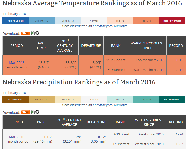
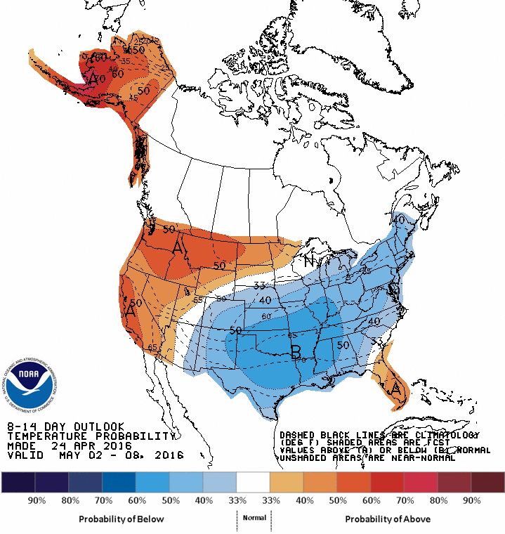
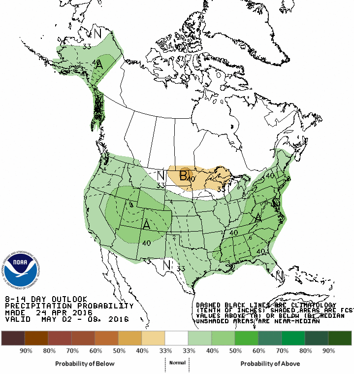
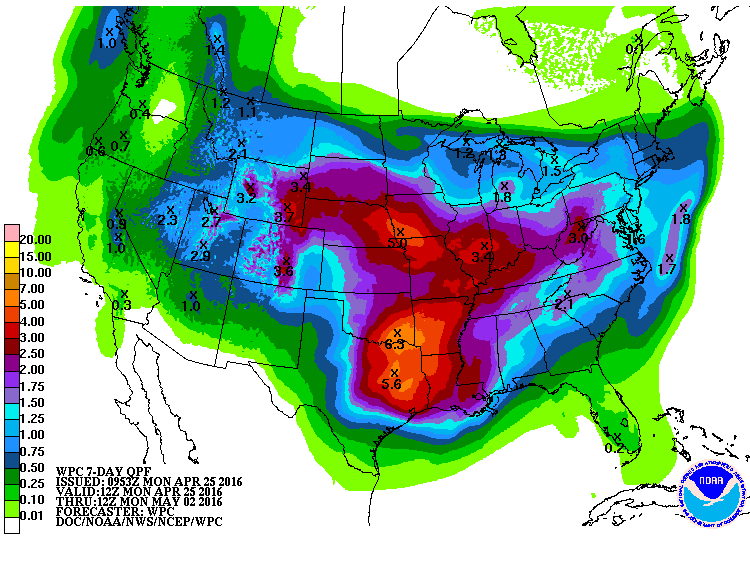
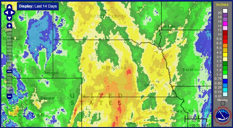
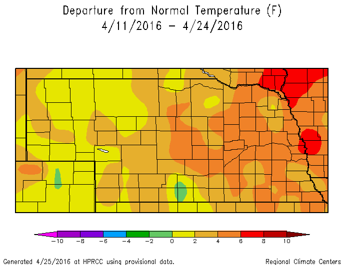
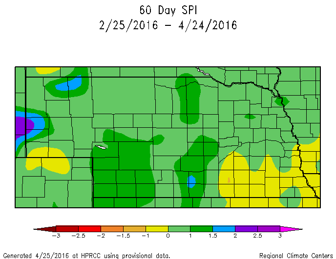
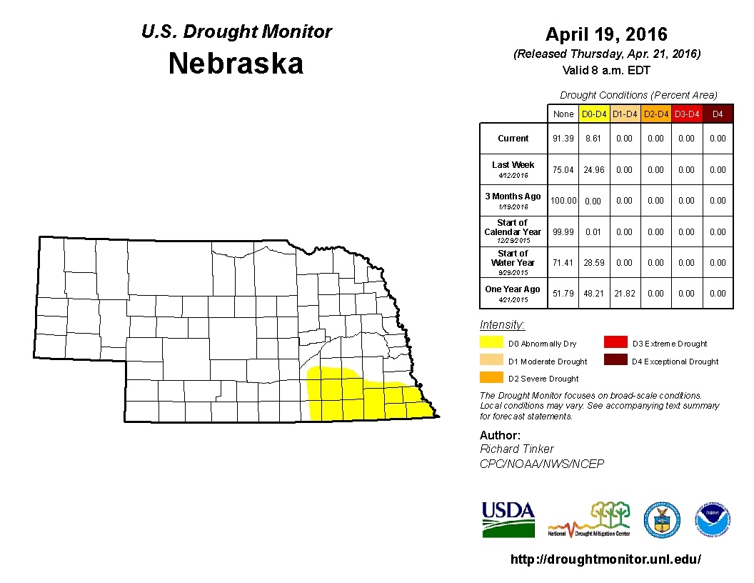
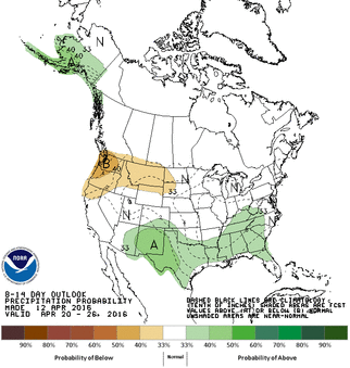
As expected, the "abnormally dry" area decreased in Nebraska in the latest Drought Monitor. A small area in south central/southeast Nebraska remains even after moderate precipitation this past week. This area is still trending below normal precipitation in the window between 30-90 days ago, but rain in the forecast just might eliminate all of the Drought Monitor colors in Nebraska by this time next week. 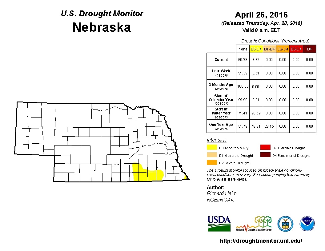 Here is a map and short-text version of the latest weather and climate news in Nebraska. Neb Rundown: - March was 5th warmest on record and near normal for precipitation. - 60-Day SPI (Standardized Precipitation Index) shows a deficit in SE Neb, which mimics the Drought Monitor. SPI is typically used to detect drought conditions during the growing season. Recent rain may alter the next drought monitor. - Estimated rainfall over the last 14 days saw 3-4" covering 2/3 of the state - 14-Day average temperature was 2-6 degrees F above normal Forecast - Severe weather is expected Tuesday for the Central Plains. Large hail and strong tornadoes possible from southern Nebraska to southern Oklahoma. Storms will initiate on warm front in Nebraska, so location of warm front in late afternoon/evening will be the key. - 7-Day precipitation forecast (QPF) shows a lot of moisture in Central Plains, up to 5"+ in E. Neb. - 8-14 Day Outlook (thru May 2-9) shows below normal temps and above normal precip during that time period for Nebraska and large portion of U.S., but could be transitioning back to warmer weather during this first week of May. Cool over the next 10 days, but does not look like hard frost risk. Get used to the 50s and 60s for highs for a while.
 Plenty of precipitation in the central 1/3 of the state, but a 90-day (and 30, 60-day) precipitation deficit still remains in the eastern 1/3. More chances for rain on the way over the next two weeks. 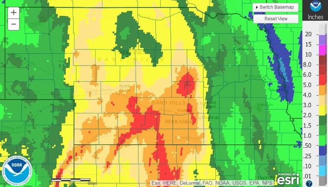 7-Day (4/19) Radar Estimate Rainfall 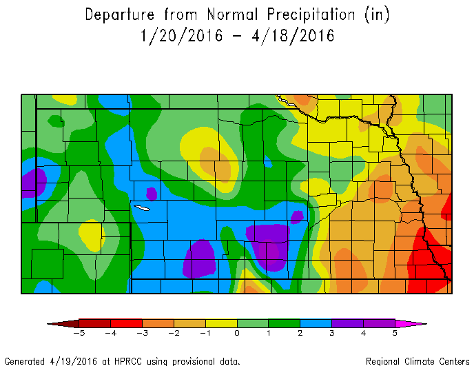 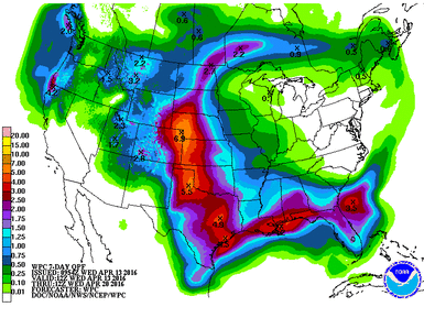 The calendar and mother nature says it is time for planting, so the fields are busy this week. The weather looks to be very good for planting for the next couple days with a big system expected to move through Friday through Sunday/Monday. Yes, that is 3 or 4 days for a system to move through, which is uncommon. This is a very amplified system and will produce a lot of moisture for someone, but probably not everyone. The 7-Day QPF shows most of the moisture in the western half of Nebraska. These values are very, very high and would pose significant issues with runoff, erosion, lowland flooding, or even heavy snow for far west portions of Nebraska. We will know more in the coming days, but precipitation is quite likely for most of the state at this point. A little moisture would be good for germination and recharge, but anything over a couple inches will run off the fields and cause problems.
The forecast for the next couple weeks looks to stay warm and relatively dry. We will see how the upper air pattern shakes out after this big system this weekend, but it looks to get back to near normal conditions over the next couple weeks. It seems there is a tendency during the spring to get these repetitive storm systems with similar storm tracks; however, the models aren't really picking this up yet. Just something to be thinking about. We saw that type of thing happen last spring in Texas and Oklahoma, as well as Eastern Nebraska. This is quite an anomalous storm system, so could be a one-time show. The CPC Outlooks keep us warm and near normal moisture through next weekend.
The upcoming storm will impact most of Nebraska and Iowa Monday and Tuesday. The warm weather over the weekend melted most of the current snow, but the pending storm will bring around a foot (+\- 6" in places) of fairly wet/heavy snow with a lot of wind. Unlike many Mid-winter snowstorms, this event is not followed by very cold temperatures and the winds will die down quickly. This will hopefully mean a speedy recovery from the winter blast. However, it looks like a big cool down is headed our way next week and bring in very cold temperatures. Our January thaw was short-lived. *On a separate note, a blizzard warning doesn't have anything to do with snowfall amounts. A blizzard warning is based on wind speed and visibility. 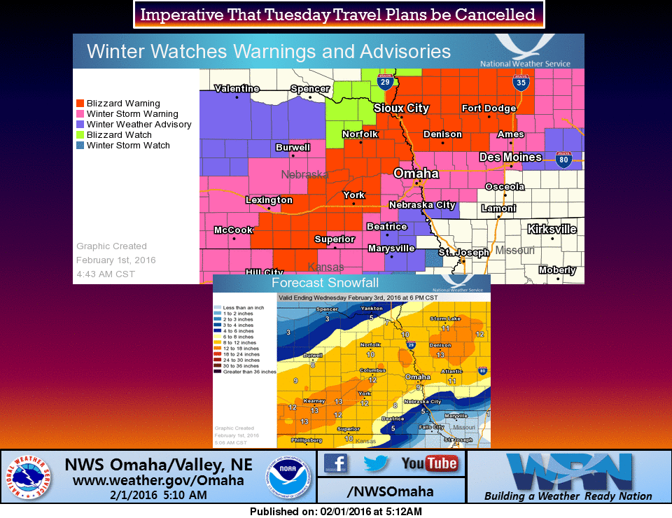 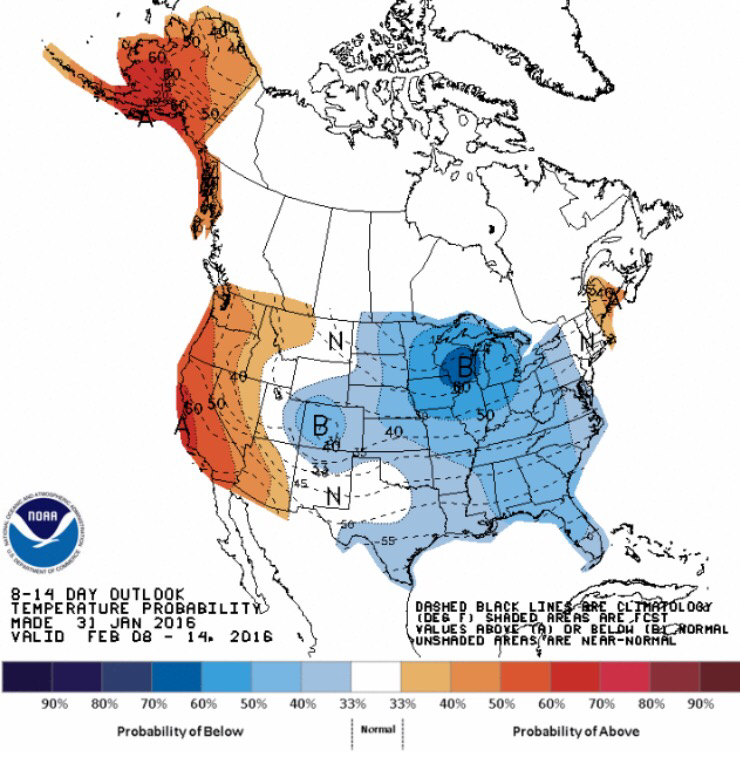 A couple of storm systems are expected to move through the heart of the country the beginning of next week and possibly the following weekend. Temperatures will remain moderate, as the flow is expected to be fairly zonal (west to east). 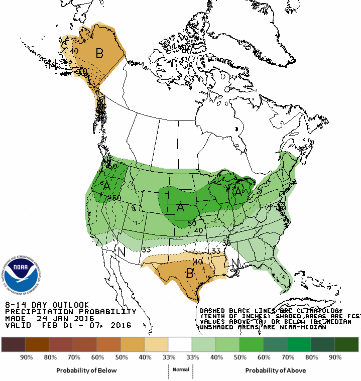 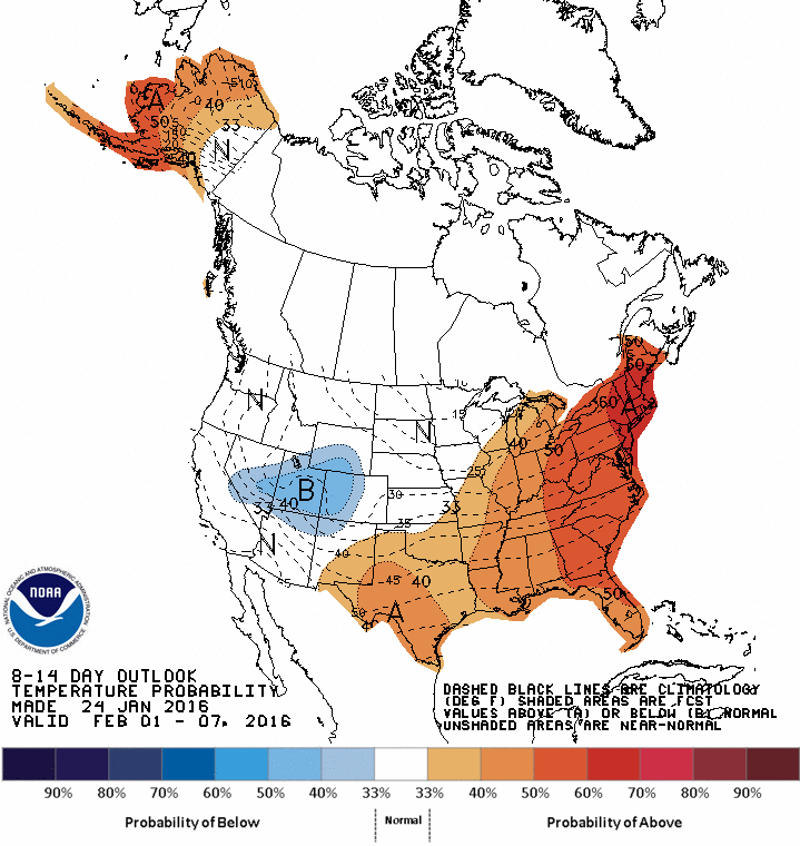 |
Ag Climate Update ArchiveAuthorI study weather and climate impacts on agriculture, climate variability, and using weather and climate information to make better agricultural decisions. Archives
March 2017
|


 RSS Feed
