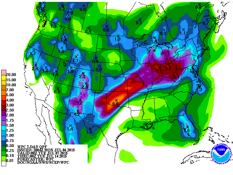
Below is the July 9, 12Z GFS accumulated precipitation animation. The accuracy of these models drop off looking past a few days, but it gives you an idea of the expected trends. Eastern U.S. may see significant moisture, while the Central and Southern Plains may see light precipitation. For the Central U.S., the drier weather may be accompanied by very warm temperatures.
1 Comment
The 7-Day QPF has heavy rain predicted from northern Texas through Ohio and keeping most of the Northern Plains fairly dry. Temperatures should be moderate, but models are projecting an increase in temperatures this weekend and into next week. The ridge that will bring in warm temperatures will also probably bring in more dry conditions. Pay attention to soil moisture to stay on top of crop needs during the critical reproduction period.
The first couple weeks of June have been fairly "normal" for most of the High Plains after a quite impressive May. The most significant impact has come from the continued rainfall in SE Nebraska and NE Kansas. Temperatures were mostly near to above normal for the High Plains, which has been welcomed after cool and cloudy weather last month. The drought monitor is pretty uneventful right now, which is always positive, especially during the growing season. Northeast Nebraska may see a little improvement in the next Monitor, but I would suspect it will remain relatively unchanged this week. The short-term forecast does show some dryer air for most of the southern High Plains with the precipitation concentrated over the Dakotas and areas east of Nebraska and Kansas. The approaching tropical storm may dump some impressive rainfall amounts over the southern plains and into the central and eastern corn belt. The forecast does not show any big changes for our weather pattern in the near future, so we may set into a near normal pattern of highs in the 80s, lows in the 60s, and small chances for isolated summer-time thunderstorms. For now, Nebraska should see some drying this week with some good growing conditions, but it may be too late for those soybean acres that have not yet been planted. The El Nino is still dominating the long-term forecast for below normal temperatures in July and August, but there is not much confidence in a detailed forecast past 7 days. Enjoy the ride of Nebraska weather.
A picture can tell a thousand words, but data can produce a lot of pictures. Studying data is often tedious, but it can provide a picture to help us understand the questions we have. This year was unique because of the unseasonably warm temperatures in March and the cold, snowy weather in mid May. This sparked a couple questions: 1) Is there a correlation between an early warm up and the last hard (28 F) freeze? 2) What is the trend in warm temperatures in March? 3) What is the trend in the date of the last hard freeze? The graphs below help to answer those questions. (click graph for larger version) THE GRAPHS The blue line represents the last time during the spring the Scottsbluff weather station hit 28 degrees Fahrenheit from 1893-2014. The scale on the left is in Julian Days, which counts the days of the year starting on January 1. (Example: 91 is April 1 and 121 is May 1) The red line is the average max temperature during March for the given year in Degrees Fahrenheit (F). The solid black line is the 10 year moving average and the dashed black line is the long-term (1893-2014) linear trend for the date for the last 28F freeze. The solid orange line is the 10 year average max March temperature and the dashed orange line is the long-term (1893-2014) average max temperature. I have not calculated statistics on this data and the trends are based on data from NOAA-ACIS and visual clues from the graphs. THE TRENDS Just quickly looking at the data, the long-term trends are easy to find. The trend for the 28F freeze date is occurring earlier at a rate of about 5 days earlier for every 132 years. That is about one day earlier every 26 years. If we assume the the date of the first fall 28F freeze remains constant (it doesn't), the growing season is actually extending over the course of the recorded data. The average max temperature trend for March is warming by about 3F every 132 years, which is a warming rate of 1F every 44 years. Depending on which years you focus on, the trends may change. If we look at the data from 1950 - 2014, the average last 28F freeze occurs 10 days later every 65 years. That is shortening our growing season by 1 day every 6.5 years, which is a trend in the opposite direction from the 132 year average. The March maximum temperature trend is warming by about 8F per 65 years from 1950-2014. That is an increasing trend of 1F every 8 years, which is a much steeper change than the 132 year average. Looking at the last 30 years of data from 1985-2014 (not pictured), the trends shift again. The trend for the date of the last 28 F freeze is that it occurs 1 day later every 6 years. The March maximum temperature trend decreased slightly and is warming 1F every 10 years. As far as the correlation between a warm March and the date of the last 28 F freeze, there does not appear to be a strong correlation between the two. Years with an early warming trend can still fall victim to a late spring cold outbreak or a change in patterns. REVIEW Looking at the long-term and short-term trends, it appears the average March maximum temperatures are indeed increasing, quite possibly at an increasing rate. However, this doesn't seem to provide any confidence in the date for a late spring hard freeze. The long-term trend for last 28F freeze is occurring earlier in the year, but the short-term trends take us later in the year. In addition, the year to year variability in the last hard freeze date is quite large, which gives us little confidence to put our crops out in the fields any earlier. If we look at 2015 data, the root of this question, the average March maximum temperature was 63 F, which is above the trendline in any given scenario. The date of the last 28F freeze was on April 21 (Julian Date=111), which is much earlier than the trendline would indicate. Even though temperatures were quite cold in May, the coldest it got was 29F on May 11, which is just above the threshold of "hard freeze". It is important to remember that this data is from one station, at one location. There are numerous microclimate impacts surrounding each individual station that can impact the measurements, thus a weather station only miles down the road may provide different data and trends. In order to make a more concrete judgement on the trends for the area, more stations should be studied. So, take this for what it is worth....an analysis of the long-term and short-term March maximum temperature data and the date of the last spring 28 F freeze at the Scottsbluff Helig AP weather station. This is a great opportunity to learn more about forage and range management. Forage and range production in Nebraska is heavily dependent on weather, so stay tuned to this blog for pertinent weather information through the year. ------------------------------------------------------------------------------------------------------- The Nebraska Extension's Mid-Plains Beef Educational Series will conduct a June session on forage and pasture management at the UNL Agricultural Research and Development Center (1071 County Road G, Ithaca) near Mead. The session will draw on the expertise of Dr. Bruce Anderson, Nebraska Extension Forage Specialist will discuss establishing pastures into previous crop ground, as well as advantages and considerations of rotational grazing. Dr. Daren Redfearn, Nebraska Extension Integrated Forage Specialist, will discuss monitoring pasture conditions - tools you can use. The session will be Monday, June 1, with registration and meal at 11:15 a.m. ---- 12:00 p.m., program beginning at 12:15 p.m. and ending at approximately 3:30 p.m. The cost is $10 by May 28, or $15 at the door (make checks available to University of Nebraska-Lincoln). Lunch and hand-outs provided. The Mid-Plains BEEF Educational Series is an effort by a team of southeastern Nebraska Extension educators. To register or obtain more information, contact: Lindsay Chichester, Saunders County, 402-624-8030; Steve Tonn, Washington County, 402-426-9455; or Monte Stauffer, Douglas/Sarpy Counties, 402-444-7804. The growth and development for corn is dependent on temperature and Growing Degree Days (GDD) are often used to determine the accumulated heat units. The most commonly used method is the Modified Growing Degree Day formula. The modification is the limit on minimum and maximum (below 50 F and above 86 F) temperature, with the assumption that corn development is limited when temperatures are below 50 F and above 86 F. When the daily maximum temperature is above 86 F it is reset to 86 F, likewise if the daily minimum temperature is below 50 F, it is reset to 50 F.
Here is the formula: ((Tmax + Tmin)/2)-50=GDD Now, you have to think back to elementary school and remember the order of operations. Start with the operations within the parenthesis, then move outward. Example: Tmax = 82 F Tmin=63 ((82+63)/2)-50=23 GDD Example 2: Tmax=93 F Tmin = 54 F (Reverts to max of 86 F) ((86+54)/2)-50=20 GDD If you have a maximum and minimum temperature recording device, you can calculate the GDD for your location, or you can go to weather.gov, click on your location, and click on "3 day history" to see daily max and min temperatures. GDD can also be found at cropwatch.unl.edu under the "weather" tab. Useful 2 Usable also has a great CornGDD tool that monitors GDD accumulation and corn growth stage. The tool can be found here. |
Ag Climate Update ArchiveAuthorI study weather and climate impacts on agriculture, climate variability, and using weather and climate information to make better agricultural decisions. Archives
March 2017
|